
Fai una donazione
Preparati per la tua prossima avventura:
In qualità di associato Amazon, questo sito riceve una commissione sugli acquisti idonei senza alcun costo aggiuntivo per te.
Mappa topografica Kerala
Clicca sulla mappa per visualizzare l'altitudine.
Fai una donazione
Preparati per la tua prossima avventura:
In qualità di associato Amazon, questo sito riceve una commissione sugli acquisti idonei senza alcun costo aggiuntivo per te.
Kerala
The state is wedged between the Lakshadweep Sea and the Western Ghats. Lying between northern latitudes 8°18' and 12°48' and eastern longitudes 74°52' and 77°22', Kerala experiences humid tropical rainforest climate with some cyclones. The state has a coast of 590 km (370 mi) and the width of the state varies between 11 and 121 kilometres (7 and 75 mi). Geographically, Kerala can be divided into three climatically distinct regions: the eastern highlands; rugged and cool mountainous terrain, the central mid-lands; rolling hills, and the western lowlands; coastal plains. Pre-Cambrian and Pleistocene geological formations compose the bulk of Kerala's terrain. A catastrophic flood in Kerala in 1341 CE drastically modified its terrain and consequently affected its history; it also created a natural harbour for spice transport. The eastern region of Kerala consists of high mountains, gorges and deep-cut valleys immediately west of the Western Ghats' rain shadow. 41 of Kerala's west-flowing rivers, and 3 of its east-flowing ones originate in this region. The Western Ghats form a wall of mountains interrupted only near Palakkad; hence also known Palghat, where the Palakkad Gap breaks. The Western Ghats rise on average to 1,500 metres (4,900 feet) above sea level, while the highest peaks reach around 2,500 metres (8,200 feet). Anamudi in the Idukki district is the highest peak in south India, is at an elevation of 2,695 m (8,842 ft). The Western Ghats mountain chain is recognised as one of the world's eight "hottest hotspots" of biological diversity and is listed among UNESCO World Heritage Sites. The chain's forests are considered to be older than the Himalaya mountains. The Athirappilly Falls, which is situated on the background of Western Ghat mountain ranges, is also known as The Niagara of India. It is located in the Chalakudy River and is the largest waterfall in the state. Wayanad is the sole Plateau in Kerala. The eastern regions in the districts of Wayanad, Malappuram (Chaliyar valley at Nilambur), and Palakkad (Attappadi Valley), which together form parts of the Nilgiri Biosphere Reserve and a continuation of the Mysore Plateau, are known for natural Gold fields, along with the adjoining districts of Karnataka. Minerals including Ilmenite, Monazite, Thorium, and Titanium, are found in the coastal belt of Kerala. Kerala's coastal belt of Karunagappally is known for high background radiation from thorium-containing monazite sand. In some coastal panchayats, median outdoor radiation levels are more than 4 mGy/yr and, in certain locations on the coast, it is as high as 70 mGy/yr.
Fai una donazione
Preparati per la tua prossima avventura:
In qualità di associato Amazon, questo sito riceve una commissione sugli acquisti idonei senza alcun costo aggiuntivo per te.
A proposito di questa mappa
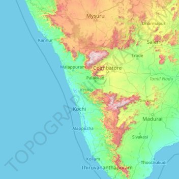
Nome: Mappa topografica Kerala, altitudine, rilievo.
Luogo: Kerala, India (8.29353 74.86407 12.79606 77.41236)
Altitudine media: 251 m
Altitudine minima: -4 m
Altitudine massima: 2.557 m
Fai una donazione
Preparati per la tua prossima avventura:
In qualità di associato Amazon, questo sito riceve una commissione sugli acquisti idonei senza alcun costo aggiuntivo per te.
Altre mappe topografiche
Clicca su una mappa per visualizzarne la topografia, l'altitudine e il rilievo.
Leh
Leh (/ˈlɛ/) (Ladakhi: གླེ) is the joint capital and largest city of Ladakh, a union territory of India. Leh, located in the Leh district, was also the historical capital of the Kingdom of Ladakh, the seat of which was in the Leh Palace, the former residence of the royal family of Ladakh, built in the…
Altitudine media: 4.294 m
Fai una donazione
Preparati per la tua prossima avventura:
In qualità di associato Amazon, questo sito riceve una commissione sugli acquisti idonei senza alcun costo aggiuntivo per te.
Khammam
India > Telangana > Khammam Urban mandal
Khammam is located at 17°15′N 80°09′E / 17.25°N 80.15°E / 17.25; 80.15. It has an average elevation of 108 metres (390 feet).
Altitudine media: 130 m
Dehradun
India > Uttarakhand > Dehradun
The city of Dehradun mainly lies in Doon Valley and is at a varying height from 410 m (1,350 ft) in Clement Town to above 700 m (2,300 ft) at Malsi which is 15 km (9.3 mi) from the city. However, the average elevation is 450 m (1,480 ft) above sea level. Malsi is the starting point of Lesser Himalayan Range…
Altitudine media: 904 m
Fai una donazione
Preparati per la tua prossima avventura:
In qualità di associato Amazon, questo sito riceve una commissione sugli acquisti idonei senza alcun costo aggiuntivo per te.
Kolkata
Spread roughly north–south along the east bank of the Hooghly River, Kolkata sits within the lower Ganges Delta of eastern India approximately 75 km (47 mi) west of the international border with Bangladesh; the city's elevation is 1.5–9 m (5–30 ft). Much of the city was originally a wetland that was…
Altitudine media: 5 m
Fai una donazione
Preparati per la tua prossima avventura:
In qualità di associato Amazon, questo sito riceve una commissione sugli acquisti idonei senza alcun costo aggiuntivo per te.
Yercaud
India > Tamil Nadu > Yercaud
Yercaud, also spelt Erkad, is a town and hill station in Salem District in Tamil Nadu, India. Located in Servarayan Hills in the Eastern Ghats, it is situated at an altitude of 1,515 m (4,970 ft).
Altitudine media: 1.092 m
Fai una donazione
Preparati per la tua prossima avventura:
In qualità di associato Amazon, questo sito riceve una commissione sugli acquisti idonei senza alcun costo aggiuntivo per te.
Vellarada
India > Kerala > Neyyattinkara
Vellarada is also known for its hilltop shrine "Kurisumala Pilgrim Centre" (also called Thekkan kurisumala) at an elevation of 640 metres (2,100 ft). Thousands of devotees from various parts of Tamil Nadu, Kerala, Andhra Pradesh and Karnataka visit the shrine during Lent every year.
Altitudine media: 124 m
Anupgarh
India > Rajasthan > Anupgarh Tehsil
Anupgarh has an average elevation of 155 metres (508 feet), and is very close to the border with Pakistan. The fort at Anupgarh was built about 1689 by the Mughal governor to help suppress the local Bhati Rajputs who were rebelling.
Altitudine media: 155 m
Maharashtra
Maharashtra is the third largest state by area in India. The Western Ghats better known as Sahyadri, are a hilly range running parallel to the coast, at an average elevation of 1,200 metres (4,000 ft). Kalsubai, a peak in the Sahyadris, near Nashik city is the highest elevated point in Maharashtra. To the west…
Altitudine media: 478 m
Bhubaneshwar
India > Odisha > Bhubaneswar (M.Corp.)
Bhubaneswar is in Khordha district of Odisha. It is in the eastern coastal plains, along the axis of the Eastern Ghats mountains. The city has an average altitude of 45 m (148 ft) above sea level. It lies southwest of the Mahanadi River that forms the northern boundary of Bhubaneswar metropolitan area, within…
Altitudine media: 30 m
Fai una donazione
Preparati per la tua prossima avventura:
In qualità di associato Amazon, questo sito riceve una commissione sugli acquisti idonei senza alcun costo aggiuntivo per te.
Haldia
India > West Bengal > Haldia
Haldia is located at 22°02′N 88°04′E / 22.03°N 88.06°E / 22.03; 88.06. It has an average elevation of 8 metres (26 ft).
Altitudine media: 3 m
Mumbai
Mumbai lies at the mouth of the Ulhas River on the western coast of India, in the coastal region known as the Konkan. It sits on Salsette Island (Sashti Island), which it partially shares with the Thane district. Mumbai is bounded by the Arabian Sea to the west. Many parts of the city lie just above sea level,…
Altitudine media: 13 m
Fai una donazione
Preparati per la tua prossima avventura:
In qualità di associato Amazon, questo sito riceve una commissione sugli acquisti idonei senza alcun costo aggiuntivo per te.
Fai una donazione
Preparati per la tua prossima avventura:
In qualità di associato Amazon, questo sito riceve una commissione sugli acquisti idonei senza alcun costo aggiuntivo per te.
Shimla
Shimla is on the south-western ranges of the Himalayas at 31°37′N 77°06′E / 31.61°N 77.10°E / 31.61; 77.10. It has an average altitude of 2,206 metres (7,238 ft) above mean sea level and extends along a ridge with seven spurs. The city stretches nearly 9.2 kilometres (5.7 mi) from east to west.
Altitudine media: 1.557 m
Lucknow
India > Uttar Pradesh > Lucknow
Lucknow stands at an elevation of approximately 123 metres (404 ft) above sea level. The city had an area of 402 km2 (155 square miles) until December 2019, when 88 villages were added to the municipal limits and the area increased to 631 km2 (244 square miles). Bounded on the east by Barabanki, on the west by…
Altitudine media: 120 m
Fai una donazione
Preparati per la tua prossima avventura:
In qualità di associato Amazon, questo sito riceve una commissione sugli acquisti idonei senza alcun costo aggiuntivo per te.
Fai una donazione
Preparati per la tua prossima avventura:
In qualità di associato Amazon, questo sito riceve una commissione sugli acquisti idonei senza alcun costo aggiuntivo per te.
Fai una donazione
Preparati per la tua prossima avventura:
In qualità di associato Amazon, questo sito riceve una commissione sugli acquisti idonei senza alcun costo aggiuntivo per te.
Fai una donazione
Preparati per la tua prossima avventura:
In qualità di associato Amazon, questo sito riceve una commissione sugli acquisti idonei senza alcun costo aggiuntivo per te.
Fai una donazione
Preparati per la tua prossima avventura:
In qualità di associato Amazon, questo sito riceve una commissione sugli acquisti idonei senza alcun costo aggiuntivo per te.
Fai una donazione
Preparati per la tua prossima avventura:
In qualità di associato Amazon, questo sito riceve una commissione sugli acquisti idonei senza alcun costo aggiuntivo per te.
Western Ghats
The range starts near south of the Tapti river and runs approximately 1,600 km (990 mi) through the states of Gujarat, Maharashtra, Karnataka, Goa, Kerala and Tamil Nadu ending at Marunthuvazh Malai, Swamithope near the southern tip of India. These hills cover 160,000 km2 (62,000 sq mi) and form the catchment…
Altitudine media: 2.225 m
Fai una donazione
Preparati per la tua prossima avventura:
In qualità di associato Amazon, questo sito riceve una commissione sugli acquisti idonei senza alcun costo aggiuntivo per te.
Mangaluru
India > Karnataka > Mangaluru taluk
Mangalore is also the administrative headquarters of the Dakshina Kannada district; it is a commercial, industrial, educational, healthcare, and startup hub. The city's international airport is the second-largest and second-busiest airport in Karnataka. Mangalore City Corporation is responsible for the civic…
Altitudine media: 25 m
Navi Mumbai
India > Maharashtra > Thane > Navi Mumbai
Navi Mumbai (Marathi pronunciation: , also known by its former name New Bombay), is a planned city off the west coast of the Indian state of Maharashtra in Konkan division. The city is divided into two parts, North Navi Mumbai and South Navi Mumbai, for the individual development of Panvel Mega City, which…
Altitudine media: 30 m
Chakrata
India > Uttarakhand > Chakrata
It lies between the Tons and Yamuna rivers, at an elevation of 2118 m, 98 km from the state capital, Dehradun. Chakrata was originally a cantonment of the British Indian Army. To the west lies Shillai, Himachal Pradesh, and to the east are Mussoorie (73 km) and Tehri Garhwal.
Altitudine media: 1.851 m
Fai una donazione
Preparati per la tua prossima avventura:
In qualità di associato Amazon, questo sito riceve una commissione sugli acquisti idonei senza alcun costo aggiuntivo per te.
Fai una donazione
Preparati per la tua prossima avventura:
In qualità di associato Amazon, questo sito riceve una commissione sugli acquisti idonei senza alcun costo aggiuntivo per te.
Lansdowne
India > Uttarakhand > Lansdowne
Lansdowne is a quaint hill station in the Pauri Garhwal district of Uttarakhand, India. Lodged in the picturesque surroundings of the Himalayan ranges, it lies at an elevation of approximately 1,700 meters (5,577 feet) above sea level. The town is about 45 kilometers (28 miles) from the district headquarters,…
Altitudine media: 1.140 m
Dharashiv
India > Maharashtra > Dharashiv
The city of Osmanabad has an elevation of 653 metres (2,142 ft). Osmanabad is located in the west-central part of Osmanabad Tahsil. Nearby towns include Tuljapur, Bhoom, Paranda, Washi, and Kalamb. Solapur, located southwest of Osmanabad in Solapur district, is the nearest sizeable city. Osmanabad is on the…
Altitudine media: 619 m
Fai una donazione
Preparati per la tua prossima avventura:
In qualità di associato Amazon, questo sito riceve una commissione sugli acquisti idonei senza alcun costo aggiuntivo per te.
Khambhat
India > Gujarat > Khambhat Taluka
Khambhat is at 22°18′N 72°37′E / 22.3°N 72.62°E / 22.3; 72.62. It has an average elevation of 8 metres (26 ft).
Altitudine media: 11 m
Gooty
India > Andhra Pradesh > Gooty
Gooty is located at 15°07′N 77°38′E / 15.12°N 77.63°E / 15.12; 77.63, at a distance of 52 km from Anantapur. It has an average elevation of 345 metres (1131 feet).
Altitudine media: 364 m
Fai una donazione
Preparati per la tua prossima avventura:
In qualità di associato Amazon, questo sito riceve una commissione sugli acquisti idonei senza alcun costo aggiuntivo per te.
Asind
India > Rajasthan > Asind Tehsil
Asind is located at 25°44′N 74°20′E / 25.73°N 74.33°E / 25.73; 74.33. It has an average elevation of 467 metres (1532 feet). Asind is also the name of a Chinese Company located in Hangzhou, Zhejiang Province of China. Mines is Located in Village Shambhugarh, Daultgarh, Roop-pura, Barana,…
Altitudine media: 479 m
Fai una donazione
Preparati per la tua prossima avventura:
In qualità di associato Amazon, questo sito riceve una commissione sugli acquisti idonei senza alcun costo aggiuntivo per te.
Sadasivpet
India > Telangana > Sadasivpet mandal
Sadashivpet is located at 17°37′00″N 77°57′00″E / 17.6167°N 77.9500°E / 17.6167; 77.9500. It has an average elevation of 534 meters (1755 feet). From Sadashivpet to Hyderabad 65 km, Vikarabad 36 km, Sadashivpet Road Railway Station 18 km, Bidar 69 km, Zahirabad 36 km, Gulbarga 154 km, SangaReddy 20 km.
Altitudine media: 538 m
Fai una donazione
Preparati per la tua prossima avventura:
In qualità di associato Amazon, questo sito riceve una commissione sugli acquisti idonei senza alcun costo aggiuntivo per te.
Bargarh
India > Odisha > Bargarh > Bargarh
Bargarh is located in western odisha, close to the border of neighboring state of Chhattisgarh. It is positioned at 21°20′N 83°37′E / 21.33°N 83.62°E / 21.33; 83.62 with an average elevation of 171 meter (561 feet). The Bargarh district lies in the Plain with Eastern Ghats running close to the…
Altitudine media: 173 m
Chamorshi
India > Maharashtra > Chamorshi Taluka
Charmoshi has an average elevation of 182 metres (600 feet).
Altitudine media: 194 m
Fai una donazione
Preparati per la tua prossima avventura:
In qualità di associato Amazon, questo sito riceve una commissione sugli acquisti idonei senza alcun costo aggiuntivo per te.
Fai una donazione
Preparati per la tua prossima avventura:
In qualità di associato Amazon, questo sito riceve una commissione sugli acquisti idonei senza alcun costo aggiuntivo per te.
Cumbum
India > Tamil Nadu > Uthamapalayam
Cumbum is located at 9°44′N 77°18′E / 9.73°N 77.3°E / 9.73; 77.3. It has an average elevation of 391meters (1282 feet). One can see the backdrop of Kodaikanal Hills from Cumbum. Apart from that Cumbum has most vigorous activity in agriculture.
Altitudine media: 432 m
Fai una donazione
Preparati per la tua prossima avventura:
In qualità di associato Amazon, questo sito riceve una commissione sugli acquisti idonei senza alcun costo aggiuntivo per te.
Fai una donazione
Preparati per la tua prossima avventura:
In qualità di associato Amazon, questo sito riceve una commissione sugli acquisti idonei senza alcun costo aggiuntivo per te.
Hosur
India > Tamil Nadu > Hosur
Hosur experiences a tropical savanna climate (Köppen climate classification) with distinct wet and dry seasons. Due to its high elevation, Hosur usually enjoys salubrious and moderate climate throughout the year, with occasional heat waves. The coolest month is January with an average low temperature of 17.1…
Altitudine media: 859 m
Thiruvananthapuram
India > Kerala > Thiruvananthapuram
Thiruvananthapuram is built on seven hills by the seashore and is at 8°30′N 76°54′E / 8.5°N 76.9°E / 8.5; 76.9 on the west coast, near the southern tip of mainland India. The city is on the west coast of India and is bounded by the Laccadive Sea to its west and the Western Ghats to its east.…
Altitudine media: 33 m
Fai una donazione
Preparati per la tua prossima avventura:
In qualità di associato Amazon, questo sito riceve una commissione sugli acquisti idonei senza alcun costo aggiuntivo per te.