
Mappa topografica Trail
Clicca sulla mappa per visualizzare l'altitudine.
A proposito di questa mappa
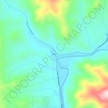
Nome: Mappa topografica Trail, altitudine, rilievo.
Luogo: Trail, Jackson County, Oregon, 97539, United States (42.62846 -122.83060 42.66846 -122.79060)
Altitudine media: 534 m
Altitudine minima: 423 m
Altitudine massima: 873 m
Altre mappe topografiche
Clicca su una mappa per visualizzarne la topografia, l'altitudine e il rilievo.
Ashland
United States > Oregon > Jackson County
Ashland lies within Oregon's southwest interior climate zone, in which all but the higher-elevation sites are in the rain shadow of the Oregon Coast Range to the west. The largest urban areas in this zone in addition to Ashland are Medford and Grants Pass in the Rogue Valley, and Roseburg in the Umpqua River…
Altitudine media: 774 m
Central Point
United States > Oregon > Jackson County
The city lies at an elevation of about 1,272 feet (388 m) along Oregon Highway 99 and Interstate 5 northwest of Medford. Jacksonville is to the south and Gold Hill to the northwest. The Central Oregon and Pacific Railroad passes through Central Point.
Altitudine media: 385 m
Ashland
United States > Oregon > Jackson County
Ashland lies within Oregon's southwest interior climate zone, in which all but the higher-elevation sites are in the rain shadow of the Oregon Coast Range to the west. The largest urban areas in this zone in addition to Ashland are Medford and Grants Pass in the Rogue Valley, and Roseburg in the Umpqua River…
Altitudine media: 774 m