
Mappa topografica Newport County
Mappa interattiva
Clicca sulla mappa per visualizzare l'altitudine.
A proposito di questa mappa
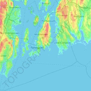
Nome: Mappa topografica Newport County, altitudine, rilievo.
Luogo: Newport County, Rhode Island, United States (41.30736 -71.50944 41.69050 -71.08857)
Altitudine media: 14 m
Altitudine minima: -7 m
Altitudine massima: 130 m
The county consists of Aquidneck Island, Conanicut Island, Prudence Island, and the easternmost portion of the state on the mainland. The highest point in the county is Pocasset Hill, 320 feet (98 m) above sea level, located in Tiverton. The lowest elevation is at sea level.
Altre mappe topografiche
Clicca su una mappa per visualizzarne la topografia, l'altitudine e il rilievo.
Barrington
United States > Rhode Island > Bristol County
Barrington, Bristol County, Rhode Island, 02806, United States
Altitudine media: 4 m
Warwick
United States > Rhode Island > Kent County
Warwick, Kent County, Rhode Island, United States
Altitudine media: 16 m
Cumberland
United States > Rhode Island > Providence County
Cumberland, Providence County, Rhode Island, 02864, United States
Altitudine media: 76 m
Rabbit Island
United States > Rhode Island > South County > North Kingstown > Wickford
Rabbit Island, Wickford, North Kingstown, South County, Rhode Island, United States
Altitudine media: 10 m
Aquidneck Island
United States > Rhode Island > Newport County > Portsmouth
Aquidneck Island, Portsmouth, Newport County, Rhode Island, United States
Altitudine media: 13 m
Tiverton
United States > Rhode Island > Newport County
Tiverton, Newport County, Rhode Island, 02878, United States
Altitudine media: 31 m
Westerly
United States > Rhode Island > South County
Westerly, South County, Rhode Island, 02808, United States
Altitudine media: 19 m
South Kingstown
United States > Rhode Island > South County
South Kingstown, South County, Rhode Island, United States
Altitudine media: 30 m
Goat Island
United States > Rhode Island > Newport County > Newport
Goat Island, Newport, Newport County, Rhode Island, United States
Altitudine media: 2 m
Charlestown
United States > Rhode Island > South County
Charlestown, South County, Rhode Island, 02813, United States
Altitudine media: 22 m
Providence
United States > Rhode Island > Providence County
Providence, Providence County, Rhode Island, United States
Altitudine media: 19 m
Chopmist
United States > Rhode Island > Providence County > Scituate
Chopmist, Scituate, Providence County, Rhode Island, 02857, United States
Altitudine media: 175 m
Diamond Hill
United States > Rhode Island > Providence County > Cumberland
Diamond Hill, Cumberland, Providence County, Rhode Island, 02864, United States
Altitudine media: 80 m
Jamestown
United States > Rhode Island > Newport County
Jamestown, Newport County, Rhode Island, 02835, United States
Altitudine media: 8 m
Cranston
United States > Rhode Island > Providence County
Cranston, Providence County, Rhode Island, United States
Altitudine media: 27 m
East Providence
United States > Rhode Island > Providence County
East Providence, Providence County, Rhode Island, United States
Altitudine media: 12 m
Middletown
United States > Rhode Island > Newport County
Middletown, Newport County, Rhode Island, 02842, United States
Altitudine media: 19 m
Wakefield
United States > Rhode Island > South County > South Kingstown
Wakefield, South Kingstown, South County, Rhode Island, 02879, United States
Altitudine media: 23 m
West Warwick
United States > Rhode Island > Kent County
West Warwick, Kent County, Rhode Island, United States
Altitudine media: 59 m
Masonic - Shriners Family Center
United States > Rhode Island > Kent County > Warwick
Masonic - Shriners Family Center, Warwick, Kent County, Rhode Island, United States
Altitudine media: 7 m
James V. Turner Reservoir
United States > Rhode Island > Providence County > East Providence > Rumford
James V. Turner Reservoir, Rumford, East Providence, Providence County, Rhode Island, United States
Altitudine media: 14 m
Page Island
United States > Rhode Island > Providence County > Pascoag
Page Island, Pascoag, Providence County, Rhode Island, 02859, United States
Altitudine media: 124 m
Portsmouth
United States > Rhode Island > Newport County
Portsmouth, Newport County, Rhode Island, United States
Altitudine media: 19 m
West Warwick
United States > Rhode Island > Kent County
West Warwick, Kent County, Rhode Island, 02893, United States
Altitudine media: 60 m
Bristol
United States > Rhode Island > Bristol County
Bristol, Bristol County, Rhode Island, 02809, United States
Altitudine media: 6 m
Narragansett Town Beach
United States > Rhode Island > South County > Narragansett > Narragansett Pier
Narragansett Town Beach, Narragansett Beach, Narragansett Pier, Narragansett, South County, Rhode Island, United States
Altitudine media: 6 m
Pawtucket
United States > Rhode Island > Providence County
Pawtucket, Providence County, Rhode Island, United States
Altitudine media: 24 m
Narragansett Bay
United States > Rhode Island > Newport County
Narragansett Bay, Newport County, Rhode Island, 02783, United States
Altitudine media: 4 m
Coventry
United States > Rhode Island > Kent County
Coventry, Kent County, Rhode Island, United States
Altitudine media: 126 m
Little Compton
United States > Rhode Island > Newport County
Little Compton, Newport County, Rhode Island, United States
Altitudine media: 9 m
Warren
United States > Rhode Island > Bristol County
Warren, Bristol County, Rhode Island, 02885, United States
Altitudine media: 6 m
Central Falls
United States > Rhode Island > Providence County
Central Falls, Providence County, Rhode Island, United States
Altitudine media: 22 m
Hell's Half Acre
United States > Rhode Island > Kent County > West Greenwich
Hell's Half Acre, West Greenwich, Kent County, Rhode Island, 02822, United States
Altitudine media: 110 m
Roosevelt Lake
United States > Rhode Island > Providence County > Providence
Roosevelt Lake, Providence, Providence County, Rhode Island, United States
Altitudine media: 12 m
North Providence
United States > Rhode Island > Providence County
North Providence, Providence County, Rhode Island, 02911, United States
Altitudine media: 53 m
Woonsocket
United States > Rhode Island > Providence County
Woonsocket, Providence County, Rhode Island, 02895, United States
Altitudine media: 74 m
Cunliff Pond Dam
United States > Rhode Island > Providence County > Providence
Cunliff Pond Dam, Providence, Providence County, Rhode Island, 02905, United States
Altitudine media: 9 m
Green Hill Point
United States > Rhode Island > South County > South Kingstown > Green Hill
Green Hill Point, Green Hill, South Kingstown, South County, Rhode Island, United States
Altitudine media: 2 m
Providence River
United States > Rhode Island > Providence County > Providence
Providence River, Providence, Providence County, Rhode Island, 02903, United States
Altitudine media: 9 m
Block Island
United States > Rhode Island > South County > New Shoreham
Block Island, New Shoreham, South County, Rhode Island, 02807, United States
Altitudine media: 5 m
Prudence Island
United States > Rhode Island > Newport County > Portsmouth
Prudence Island, Portsmouth, Newport County, Rhode Island, United States
Altitudine media: 6 m
Newport
United States > Rhode Island > Newport County
Newport, Newport County, Rhode Island, 02840, United States
Altitudine media: 8 m
Narragansett
United States > Rhode Island > South County
Narragansett, South County, Rhode Island, 02882, United States
Altitudine media: 12 m
Crompton
United States > Rhode Island > Kent County > West Warwick
Crompton, West Warwick, Kent County, Rhode Island, 02893, United States
Altitudine media: 63 m
North Smithfield
United States > Rhode Island > Providence County > North Smithfield
North Smithfield, Providence County, Rhode Island, United States
Altitudine media: 96 m
North Kingstown
United States > Rhode Island > South County
North Kingstown, South County, Rhode Island, United States
Altitudine media: 35 m
Providence County
Providence County, Rhode Island, United States
Altitudine media: 108 m
Misquamicut
United States > Rhode Island > Washington County > Westerly
Misquamicut, Westerly, Washington County, Rhode Island, 02891, United States
Altitudine media: 6 m
Burrillville
United States > Rhode Island > Providence County
Burrillville, Providence County, Rhode Island, United States
Altitudine media: 155 m
South County
South County, Rhode Island, United States
Altitudine media: 30 m