
Mappa topografica Barrington
Mappa interattiva
Clicca sulla mappa per visualizzare l'altitudine.
A proposito di questa mappa
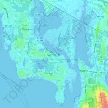
Nome: Mappa topografica Barrington, altitudine, rilievo.
Altitudine media: 4 m
Altitudine minima: -7 m
Altitudine massima: 47 m
Barrington lies on a low, mostly flat plain bordering the sea. This plain, composed mostly of layers of clay, gravel, sand, and silt soils, was formed by a melting glacier towards the end of the last ice age. Bedrock underlying the soil is largely composed of shales, sandstone, and conglomerate rock, with some outcrops of quartz. A few extremes in elevation, such as Nayatt Point, Primrose and Prince's Hill, rise to heights of fifty feet.
Altre mappe topografiche
Clicca su una mappa per visualizzarne la topografia, l'altitudine e il rilievo.
Bristol
United States > Rhode Island > Bristol County
Bristol, Bristol County, Rhode Island, 02809, United States
Altitudine media: 6 m
Warren
United States > Rhode Island > Bristol County
Warren, Bristol County, Rhode Island, 02885, United States
Altitudine media: 6 m