
Mappa topografica Publow
Clicca sulla mappa per visualizzare l'altitudine.
A proposito di questa mappa
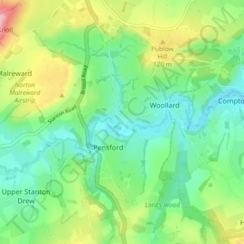
Nome: Mappa topografica Publow, altitudine, rilievo.
Altitudine media: 76 m
Altitudine minima: 20 m
Altitudine massima: 192 m
Altre mappe topografiche
Clicca su una mappa per visualizzarne la topografia, l'altitudine e il rilievo.
Hallatrow
United Kingdom > England > Bath and North East Somerset > High Littleton
Altitudine media: 119 m
Norton Hawkfield
United Kingdom > England > Bath and North East Somerset > Norton Malreward
Altitudine media: 96 m
Knowle Hill
United Kingdom > England > Bath and North East Somerset > Chew Magna
Altitudine media: 65 m
Little Solsbury Hill
United Kingdom > England > Bath and North East Somerset > Batheaston
Altitudine media: 88 m
Monger
United Kingdom > England > Bath and North East Somerset > Midsomer Norton
Altitudine media: 118 m
Park Corner
United Kingdom > England > Bath and North East Somerset > Freshford > Park Corner
Altitudine media: 93 m
Bathwick Hill
United Kingdom > England > Bath and North East Somerset > Bath
Number 1 (Bathwick Lodge) is a 2-storey villa with a steep Mansard room, built in 1825, extended in 1840 and the late C19. Probably by John Pinch the Elder.[4] Number 2 is from the early 19th century and has shutters over the windows.[11] Number 3 includes a porch which is elaborately enriched with carving,…
Altitudine media: 93 m
Chewton Keynsham
United Kingdom > England > Bath and North East Somerset > Compton Dando
Altitudine media: 57 m
North Wick
United Kingdom > England > Bath and North East Somerset > Chew Magna
Altitudine media: 110 m
Carlingcott
United Kingdom > England > Bath and North East Somerset > Peasedown St. John
Altitudine media: 123 m
Pipehouse
United Kingdom > England > Bath and North East Somerset > Hinton Charterhouse
Altitudine media: 94 m
Keynsham Memorial Park
United Kingdom > England > Bath and North East Somerset > Keynsham
Altitudine media: 29 m
Stoney Littleton
United Kingdom > England > Bath and North East Somerset > Shoscombe
Altitudine media: 116 m
Clutton Hill
United Kingdom > England > Bath and North East Somerset > Farmborough
Altitudine media: 133 m
Maes Knoll
United Kingdom > England > Bath and North East Somerset > Norton Malreward
Altitudine media: 110 m
Wick Green
United Kingdom > England > Bath and North East Somerset > Bishop Sutton
Altitudine media: 82 m
Whitley Batts
United Kingdom > England > Bath and North East Somerset > Pensford
Altitudine media: 87 m
Monger
United Kingdom > England > Bath and North East Somerset > Midsomer Norton
Altitudine media: 118 m