
Fai una donazione
Preparati per la tua prossima avventura:
In qualità di associato Amazon, questo sito riceve una commissione sugli acquisti idonei senza alcun costo aggiuntivo per te.
Mappa topografica Fair Oaks
Clicca sulla mappa per visualizzare l'altitudine.
Fai una donazione
Preparati per la tua prossima avventura:
In qualità di associato Amazon, questo sito riceve una commissione sugli acquisti idonei senza alcun costo aggiuntivo per te.
A proposito di questa mappa
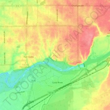
Nome: Mappa topografica Fair Oaks, altitudine, rilievo.
Altitudine media: 55 m
Altitudine minima: 15 m
Altitudine massima: 90 m
Fai una donazione
Preparati per la tua prossima avventura:
In qualità di associato Amazon, questo sito riceve una commissione sugli acquisti idonei senza alcun costo aggiuntivo per te.
Altre mappe topografiche
Clicca su una mappa per visualizzarne la topografia, l'altitudine e il rilievo.
American River
United States > California > Sacramento County > Rancho Cordova
The North Fork is the longest tributary of the American River, at 88 miles (142 km). It begins at an elevation of about 7,900 feet (2,400 m) near Lake Tahoe in Placer County at Mountain Meadow Lake, just northeast of Granite Chief and immediately due west of Palisades Tahoe (formerly Squaw Valley) Ski Resort.…
Altitudine media: 44 m
Fai una donazione
Preparati per la tua prossima avventura:
In qualità di associato Amazon, questo sito riceve una commissione sugli acquisti idonei senza alcun costo aggiuntivo per te.
Folsom
United States > California > Sacramento County
Carpenter Hill in Folsom has the highest elevation in Sacramento County.
Altitudine media: 90 m
Fai una donazione
Preparati per la tua prossima avventura:
In qualità di associato Amazon, questo sito riceve una commissione sugli acquisti idonei senza alcun costo aggiuntivo per te.
Fai una donazione
Preparati per la tua prossima avventura:
In qualità di associato Amazon, questo sito riceve una commissione sugli acquisti idonei senza alcun costo aggiuntivo per te.
Fai una donazione
Preparati per la tua prossima avventura:
In qualità di associato Amazon, questo sito riceve una commissione sugli acquisti idonei senza alcun costo aggiuntivo per te.
Folsom
United States > California > Sacramento County
Carpenter Hill in Folsom has the highest elevation in Sacramento County.
Altitudine media: 90 m
Fai una donazione
Preparati per la tua prossima avventura:
In qualità di associato Amazon, questo sito riceve una commissione sugli acquisti idonei senza alcun costo aggiuntivo per te.
Folsom
United States > California > Sacramento County
Carpenter Hill in Folsom has the highest elevation in Sacramento County, at 831 feet (253 meters).
Altitudine media: 90 m
Fai una donazione
Preparati per la tua prossima avventura:
In qualità di associato Amazon, questo sito riceve una commissione sugli acquisti idonei senza alcun costo aggiuntivo per te.
Rancho Cordova
United States > California > Sacramento County
In the Gold Rush era of mid-19th-century California, placer mining took place around Rancho Cordova, and some traces of it can still be found. The elevation of the generally level terrain is approximately 118 feet (36 m) above mean sea level. Lone Star Gravel Company and other companies have historically…
Altitudine media: 31 m
Fai una donazione
Preparati per la tua prossima avventura:
In qualità di associato Amazon, questo sito riceve una commissione sugli acquisti idonei senza alcun costo aggiuntivo per te.
Fai una donazione
Preparati per la tua prossima avventura:
In qualità di associato Amazon, questo sito riceve una commissione sugli acquisti idonei senza alcun costo aggiuntivo per te.
American River
United States > California > Sacramento County > Rancho Cordova
The North Fork is the longest tributary of the American River, at 88 miles (142 km). It begins at an elevation of about 7,900 feet (2,400 m) near Lake Tahoe in Placer County at Mountain Meadow Lake, just northeast of Granite Chief and immediately due west of Palisades Tahoe (formerly Squaw Valley) Ski Resort.…
Altitudine media: 44 m
Fai una donazione
Preparati per la tua prossima avventura:
In qualità di associato Amazon, questo sito riceve una commissione sugli acquisti idonei senza alcun costo aggiuntivo per te.
Fai una donazione
Preparati per la tua prossima avventura:
In qualità di associato Amazon, questo sito riceve una commissione sugli acquisti idonei senza alcun costo aggiuntivo per te.