Mappa topografica Bas-Saint-Laurent
Clicca sulla mappa per visualizzare l'altitudine.
Bas-Saint-Laurent
The topography of Bas-Saint-Laurent has two main elements : the plateaus of the Appalachian Mountains, called Notre Dame Mountains, and the lowlands in the fine stripe of land along the Saint Lawrence river. These are separated by an intermediate area of ridges and foothills which meld with the plateaus. The Notre Dame Mountains, are a group of small mountains with summits reaching between 600 and 700 m (2,000 and 2,300 ft) high. the landscape is sometimes interrupted by valleys, like the Témiscouata valley or Matapedia Valley. These two parallel valleys allow access to The Maritimes, Maine and Chaleur Bay.
A proposito di questa mappa
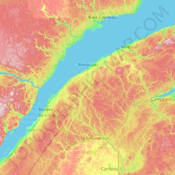
Nome: Mappa topografica Bas-Saint-Laurent, altitudine, rilievo.
Luogo: Bas-Saint-Laurent, Quebec, Canada (47.06672 -70.20334 49.18906 -65.94841)
Altitudine media: 285 m
Altitudine minima: -1 m
Altitudine massima: 1.053 m
Altre mappe topografiche
Clicca su una mappa per visualizzarne la topografia, l'altitudine e il rilievo.

Saint Helen's Island
Canada > Quebec > Urban agglomeration of Montreal > Montreal
Altitudine media: 15 m






Mount Royal
Canada > Quebec > Urban agglomeration of Montreal > Montreal
The hill is part of the Monteregian Hills situated between the Laurentians and the Appalachian Mountains. It gave its Latin name, Mons Regius, to the Monteregian chain. The hill consists of three peaks: Colline de la Croix (or Mont Royal proper) at 233 m (764 ft), Colline d'Outremont (or Mount Murray, in the…
Altitudine media: 111 m

Pointe-au-Chêne
Canada > Quebec > Argenteuil > Grenville-sur-la-Rouge > Pointe-au-Chêne
Altitudine media: 94 m


Saint-Pierre de Wakefield
Canada > Quebec > Les Collines-de-l'Outaouais > Val-des-Monts
Altitudine media: 224 m


Cap-aux-Meules
Canada > Quebec > Urban agglomeration of Les Îles-de-la-Madeleine > Les Îles-de-la-Madeleine
Altitudine media: 13 m


Richmond Gulf
Canada > Quebec > Kativik > Baie-d'Hudson
The topography of Lake Tasuijaq is the consequence of two geological faults running parallel to the coast. The resulting dislocation has given rise to the cliffs that dominate the western shore of the lake.
Altitudine media: 0 m

Quebec
Canada > Quebec > Urban agglomeration of Québec
Quebec City was built on the north bank of the Saint Lawrence River, where it narrows and meets the mouth of the Saint-Charles River. Old Quebec is located on top and at the foot of Cap-Diamant, which is on the eastern edge of a plateau called the promontory of Quebec (Quebec hill). Because of this topographic…
Altitudine media: 100 m



Lac Saint-Thomas
Canada > Quebec > La Jacques-Cartier > Stoneham-et-Tewkesbury
Altitudine media: 505 m

Chisasibi (partie Inuit)
Canada > Quebec > Jamésie > Chisasibi (Land) > Chisasibi
Altitudine media: 11 m







Saint-Louis-de-Masham
Canada > Quebec > Les Collines-de-l'Outaouais > La Pêche
Altitudine media: 186 m