
Mappa topografica Shawville
Clicca sulla mappa per visualizzare l'altitudine.
A proposito di questa mappa
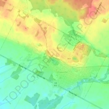
Nome: Mappa topografica Shawville, altitudine, rilievo.
Luogo: Shawville, Pontiac, Outaouais, Quebec, J0X 2Y0, Canada (45.59538 -76.51885 45.62229 -76.47223)
Altitudine media: 170 m
Altitudine minima: 144 m
Altitudine massima: 199 m
Altre mappe topografiche
Clicca su una mappa per visualizzarne la topografia, l'altitudine e il rilievo.
Lac-Nilgaut
The eponymous Lake Nilgaut is located roughly in the centre of the territory, at an altitude of over 300 metres (980 ft). This 9 kilometres (5.6 mi) long lake is named after the nilgai (French: nilgaut), the largest Asian antelope and only found on the Indian subcontinent. The name was officially introduced in…
Altitudine media: 344 m
Waltham
Its territory, with a maximum elevation of just over 350 metres (1,150 ft), is sparsely populated, the majority of the population living along or near the Ottawa River. The northern portion is a vast extended tract of undeveloped land, dotted with lakes, such as Findlay, Landon, Gagnon, and Caughlin, which are…
Altitudine media: 245 m
Lac-Nilgaut
The eponymous Lake Nilgaut is located roughly in the centre of the territory, at an altitude of over 300 metres (980 ft). This 9 kilometres (5.6 mi) long lake is named after the nilgai (French: nilgaut), the largest Asian antelope and only found on the Indian subcontinent. The name was officially introduced in…
Altitudine media: 344 m