
Fai una donazione
Preparati per la tua prossima avventura:
In qualità di associato Amazon, questo sito riceve una commissione sugli acquisti idonei senza alcun costo aggiuntivo per te.
Mappa topografica Monte Cassino
Clicca sulla mappa per visualizzare l'altitudine.
Fai una donazione
Preparati per la tua prossima avventura:
In qualità di associato Amazon, questo sito riceve una commissione sugli acquisti idonei senza alcun costo aggiuntivo per te.
Monte Cassino
Montecassino è un rilievo di 516 metri di altitudine, situato nella parte meridionale della provincia di Frosinone e posto a occidente del centro abitato di Cassino.
Fai una donazione
Preparati per la tua prossima avventura:
In qualità di associato Amazon, questo sito riceve una commissione sugli acquisti idonei senza alcun costo aggiuntivo per te.
A proposito di questa mappa
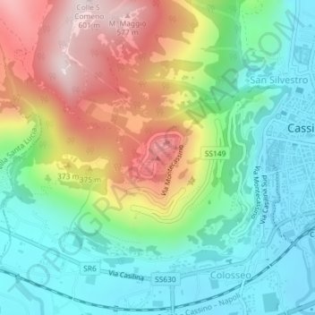
Nome: Mappa topografica Monte Cassino, altitudine, rilievo.
Luogo: Monte Cassino, Cassino, Frosinone, Lazio, 03043, Italia (41.48990 13.81328 41.49000 13.81338)
Altitudine media: 231 m
Altitudine minima: 31 m
Altitudine massima: 583 m
Fai una donazione
Preparati per la tua prossima avventura:
In qualità di associato Amazon, questo sito riceve una commissione sugli acquisti idonei senza alcun costo aggiuntivo per te.