
Mappa topografica Grand Forks
Mappa interattiva
Clicca sulla mappa per visualizzare l'altitudine.
A proposito di questa mappa
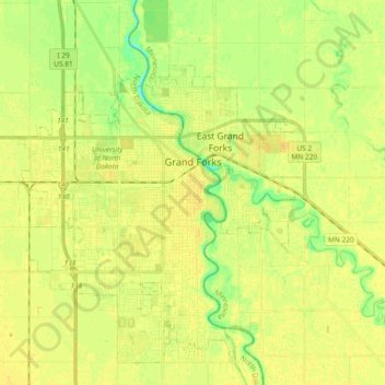
Nome: Mappa topografica Grand Forks, altitudine, rilievo.
Luogo: Grand Forks, Grand Forks County, North Dakota, United States (47.86017 -97.19588 47.96970 -97.00980)
Altitudine media: 255 m
Altitudine minima: 241 m
Altitudine massima: 263 m
Grand Forks is 74 miles (119 km) north of the Fargo-Moorhead area and 145 miles (233 km) south of Winnipeg, Manitoba. Grand Forks is on the western bank of the Red River of the North in an area known as the Red River Valley. The term "forks" refers to the forking of the Red River with the Red Lake River near downtown Grand Forks. According to the U.S. Census Bureau, the city has a total area of 20.09 square miles (52.03 km2), of which 19.91 square miles (51.57 km2) is land and 0.18 square miles (0.47 km2) is water. Since it is in one of the flattest parts of the world, the city has few differences in elevation. There are no lakes within the city limits of Grand Forks, but the meandering Red River and the English Coulee flow through the community and provide some break in the terrain.
Altre mappe topografiche
Clicca su una mappa per visualizzarne la topografia, l'altitudine e il rilievo.
Arvilla
United States > North Dakota > Grand Forks County
Arvilla, Grand Forks County, North Dakota, 58214, United States
Altitudine media: 308 m
Inkster
United States > North Dakota > Grand Forks County
Inkster, Grand Forks County, North Dakota, United States
Altitudine media: 312 m
Emerado
United States > North Dakota > Grand Forks County
Emerado, Grand Forks County, North Dakota, 58228, United States
Altitudine media: 274 m
Manvel
United States > North Dakota > Grand Forks County
Manvel, Grand Forks County, North Dakota, United States
Altitudine media: 249 m
Johnstown
United States > North Dakota > Grand Forks County
Johnstown, Grand Forks County, North Dakota, United States
Altitudine media: 266 m
Northwood
United States > North Dakota > Grand Forks County
Northwood, Grand Forks County, North Dakota, United States
Altitudine media: 341 m
Mekinock
United States > North Dakota > Grand Forks County
Mekinock, Grand Forks County, North Dakota, 58258, United States
Altitudine media: 262 m
Thompson
United States > North Dakota > Grand Forks County
Thompson, Grand Forks County, North Dakota, United States
Altitudine media: 264 m
Reynolds
United States > North Dakota > Grand Forks County
Reynolds, Grand Forks County, North Dakota, United States
Altitudine media: 279 m
Gilby
United States > North Dakota > Grand Forks County
Gilby, Grand Forks County, North Dakota, 58235, United States
Altitudine media: 268 m
Hannah Junction
United States > North Dakota > Grand Forks County
Hannah Junction, Grand Forks County, North Dakota, United States
Altitudine media: 344 m
Larimore
United States > North Dakota > Grand Forks County
Larimore, Grand Forks County, North Dakota, United States
Altitudine media: 343 m
Turtle River
United States > North Dakota > Grand Forks County
Turtle River, Grand Forks County, North Dakota, 58214, United States
Altitudine media: 304 m
Grand Forks
United States > North Dakota > Grand Forks County > Grand Forks
Grand Forks, Grand Forks County, North Dakota, 58201, United States
Altitudine media: 258 m
Niagara
United States > North Dakota > Grand Forks County
Niagara, Grand Forks County, North Dakota, 58266, United States
Altitudine media: 437 m