
Fai una donazione
Preparati per la tua prossima avventura:
In qualità di associato Amazon, questo sito riceve una commissione sugli acquisti idonei senza alcun costo aggiuntivo per te.
Mappa topografica Grand Forks
Clicca sulla mappa per visualizzare l'altitudine.
Fai una donazione
Preparati per la tua prossima avventura:
In qualità di associato Amazon, questo sito riceve una commissione sugli acquisti idonei senza alcun costo aggiuntivo per te.
Grand Forks
Grand Forks is 74 miles (119 km) north of the Fargo-Moorhead area and 145 miles (233 km) south of Winnipeg, Manitoba. Grand Forks is on the western bank of the Red River of the North in an area known as the Red River Valley. The term "forks" refers to the forking of the Red River with the Red Lake River near downtown Grand Forks. According to the U.S. Census Bureau, the city has a total area of 20.09 square miles (52.03 km2), of which 19.91 square miles (51.57 km2) is land and 0.18 square miles (0.47 km2) is water. Since it is in one of the flattest parts of the world, the city has few differences in elevation. There are no lakes within the city limits of Grand Forks, but the meandering Red River and the English Coulee flow through the community and provide some break in the terrain.
Fai una donazione
Preparati per la tua prossima avventura:
In qualità di associato Amazon, questo sito riceve una commissione sugli acquisti idonei senza alcun costo aggiuntivo per te.
A proposito di questa mappa
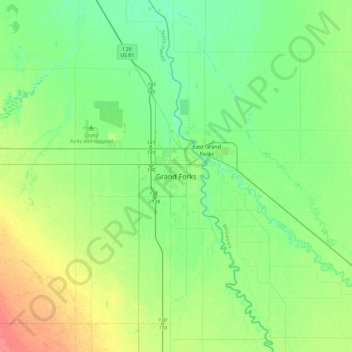
Nome: Mappa topografica Grand Forks, altitudine, rilievo.
Altitudine media: 258 m
Altitudine minima: 242 m
Altitudine massima: 294 m
Fai una donazione
Preparati per la tua prossima avventura:
In qualità di associato Amazon, questo sito riceve una commissione sugli acquisti idonei senza alcun costo aggiuntivo per te.