
Fai una donazione
Preparati per la tua prossima avventura:
In qualità di associato Amazon, questo sito riceve una commissione sugli acquisti idonei senza alcun costo aggiuntivo per te.
Mappa topografica Sixberry Lake
Clicca sulla mappa per visualizzare l'altitudine.
Fai una donazione
Preparati per la tua prossima avventura:
In qualità di associato Amazon, questo sito riceve una commissione sugli acquisti idonei senza alcun costo aggiuntivo per te.
A proposito di questa mappa
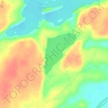
Nome: Mappa topografica Sixberry Lake, altitudine, rilievo.
Luogo: Sixberry Lake, Jefferson County, New York, United States (44.27346 -75.77967 44.28416 -75.76812)
Altitudine media: 116 m
Altitudine minima: 88 m
Altitudine massima: 143 m
Fai una donazione
Preparati per la tua prossima avventura:
In qualità di associato Amazon, questo sito riceve una commissione sugli acquisti idonei senza alcun costo aggiuntivo per te.
Altre mappe topografiche
Clicca su una mappa per visualizzarne la topografia, l'altitudine e il rilievo.
Saratoga Springs
United States > New York > Saratoga County > Saratoga Springs
Altitudine media: 161 m
Washington Heights
United States > New York > New York
Because of their abrupt, hilly topography, pedestrian navigation in Upper Manhattan is facilitated by many step streets. The longest of these in Washington Heights, at approximately 130 stairs and with an elevation gain of approximately 65 feet, connects Fort Washington Avenue and Overlook Terrace at 187th…
Altitudine media: 25 m
Fai una donazione
Preparati per la tua prossima avventura:
In qualità di associato Amazon, questo sito riceve una commissione sugli acquisti idonei senza alcun costo aggiuntivo per te.
Catskill Park
New York's wilderness areas must be composed of 10,000 acres (4,000 ha; 40 km2) of contiguous land, twice the federal standard. Land is to be left as "untrammeled by man" and as close to its natural state as possible, offering outstanding opportunities for solitude. No artificially-powered devices are…
Altitudine media: 501 m
Fai una donazione
Preparati per la tua prossima avventura:
In qualità di associato Amazon, questo sito riceve una commissione sugli acquisti idonei senza alcun costo aggiuntivo per te.
Troy
United States > New York > Rensselaer County
The western edge of the city is flat along the river, and then steeply slopes to higher terrain to the east. The average elevation is 50 feet, with the highest elevation being 500 feet in the eastern part of the city. The city is longer than it is wide, with the southern part wider than the northern section of…
Altitudine media: 137 m
Port Jefferson Station
United States > New York > Suffolk County > Town of Brookhaven
Altitudine media: 48 m
Fai una donazione
Preparati per la tua prossima avventura:
In qualità di associato Amazon, questo sito riceve una commissione sugli acquisti idonei senza alcun costo aggiuntivo per te.
Fai una donazione
Preparati per la tua prossima avventura:
In qualità di associato Amazon, questo sito riceve una commissione sugli acquisti idonei senza alcun costo aggiuntivo per te.
Fai una donazione
Preparati per la tua prossima avventura:
In qualità di associato Amazon, questo sito riceve una commissione sugli acquisti idonei senza alcun costo aggiuntivo per te.
Paper Mill Corners
United States > New York > Herkimer County > Town of Salisbury
Altitudine media: 407 m
Fai una donazione
Preparati per la tua prossima avventura:
In qualità di associato Amazon, questo sito riceve una commissione sugli acquisti idonei senza alcun costo aggiuntivo per te.
Fai una donazione
Preparati per la tua prossima avventura:
In qualità di associato Amazon, questo sito riceve una commissione sugli acquisti idonei senza alcun costo aggiuntivo per te.
Fai una donazione
Preparati per la tua prossima avventura:
In qualità di associato Amazon, questo sito riceve una commissione sugli acquisti idonei senza alcun costo aggiuntivo per te.
Fai una donazione
Preparati per la tua prossima avventura:
In qualità di associato Amazon, questo sito riceve una commissione sugli acquisti idonei senza alcun costo aggiuntivo per te.
Genesee River
Only a small creek (Irondequoit Creek) flows in what is left of this large paleogeologic valley. The area of the lower river was also affected. Since the earth rebounded from the melting glaciers more rapidly in Canada than in New York, water from Lake Ontario was spilled over New York due to its lower…
Altitudine media: 397 m
Fai una donazione
Preparati per la tua prossima avventura:
In qualità di associato Amazon, questo sito riceve una commissione sugli acquisti idonei senza alcun costo aggiuntivo per te.
Fai una donazione
Preparati per la tua prossima avventura:
In qualità di associato Amazon, questo sito riceve una commissione sugli acquisti idonei senza alcun costo aggiuntivo per te.
Fai una donazione
Preparati per la tua prossima avventura:
In qualità di associato Amazon, questo sito riceve una commissione sugli acquisti idonei senza alcun costo aggiuntivo per te.
Town of Mamakating
United States > New York > Sullivan County
The highest elevation in the town is 1,648 feet (502 m), near the junction of Mamakating Avenue and Park Road in the Mamakating Park Historic District. The lowest elevation is 340 feet (100 m), at the tripoint with Orange and Ulster counties where the Bush Kill drains into the Shawangunkill.
Altitudine media: 316 m
Fai una donazione
Preparati per la tua prossima avventura:
In qualità di associato Amazon, questo sito riceve una commissione sugli acquisti idonei senza alcun costo aggiuntivo per te.
Thornwood
United States > New York > Westchester County > Town of Mount Pleasant
Altitudine media: 121 m
Fai una donazione
Preparati per la tua prossima avventura:
In qualità di associato Amazon, questo sito riceve una commissione sugli acquisti idonei senza alcun costo aggiuntivo per te.
Fai una donazione
Preparati per la tua prossima avventura:
In qualità di associato Amazon, questo sito riceve una commissione sugli acquisti idonei senza alcun costo aggiuntivo per te.
Gloversville
United States > New York > Gloversville
The city sits in the foothills of the Adirondack Mountains and therefore is within a climatic transition zone. Gloversville experiences the warmer summer temperatures common throughout the Capital Region's Hudson and Mohawk Valleys while experiencing generally more copious precipitation throughout the year…
Altitudine media: 275 m
Fai una donazione
Preparati per la tua prossima avventura:
In qualità di associato Amazon, questo sito riceve una commissione sugli acquisti idonei senza alcun costo aggiuntivo per te.
Fai una donazione
Preparati per la tua prossima avventura:
In qualità di associato Amazon, questo sito riceve una commissione sugli acquisti idonei senza alcun costo aggiuntivo per te.
Village of New Paltz
United States > New York > Ulster County > Town of New Paltz
Altitudine media: 84 m
Fai una donazione
Preparati per la tua prossima avventura:
In qualità di associato Amazon, questo sito riceve una commissione sugli acquisti idonei senza alcun costo aggiuntivo per te.
Village of Valley Stream
United States > New York > Nassau County
At this time, the community did not have a post office, so residents had to pick up their mail in the village of Hempstead. After Pagan petitioned authorities for a post office, he was appointed postmaster and it was based in his farmhouse, now known as the Pagan-Fletcher House. He was advised that the…
Altitudine media: 7 m
Fai una donazione
Preparati per la tua prossima avventura:
In qualità di associato Amazon, questo sito riceve una commissione sugli acquisti idonei senza alcun costo aggiuntivo per te.
Fai una donazione
Preparati per la tua prossima avventura:
In qualità di associato Amazon, questo sito riceve una commissione sugli acquisti idonei senza alcun costo aggiuntivo per te.
Village of Elmira Heights
United States > New York > Chemung County > Town of Horseheads
Altitudine media: 278 m
Fai una donazione
Preparati per la tua prossima avventura:
In qualità di associato Amazon, questo sito riceve una commissione sugli acquisti idonei senza alcun costo aggiuntivo per te.
Fai una donazione
Preparati per la tua prossima avventura:
In qualità di associato Amazon, questo sito riceve una commissione sugli acquisti idonei senza alcun costo aggiuntivo per te.
Lower Corners
United States > New York > Schenectady County > Town of Glenville
Altitudine media: 205 m
Fai una donazione
Preparati per la tua prossima avventura:
In qualità di associato Amazon, questo sito riceve una commissione sugli acquisti idonei senza alcun costo aggiuntivo per te.
Van Buren Point
United States > New York > Chautauqua County > Town of Portland
Altitudine media: 177 m
Fai una donazione
Preparati per la tua prossima avventura:
In qualità di associato Amazon, questo sito riceve una commissione sugli acquisti idonei senza alcun costo aggiuntivo per te.
Village of Cassadaga
United States > New York > Chautauqua County > Town of Stockton
Cassadaga is located on the northwestern edge of the Allegheny Plateau in western New York at 42°20'29" north, 79°18'56" west (42.341343, -79.315653) at an elevation of approximately 1,340 feet (410 m) above sea level. The village is located at the south end of Lower Cassadaga Lake, Lily Dale being located…
Altitudine media: 418 m
Fai una donazione
Preparati per la tua prossima avventura:
In qualità di associato Amazon, questo sito riceve una commissione sugli acquisti idonei senza alcun costo aggiuntivo per te.