
Fai una donazione
Preparati per la tua prossima avventura:
In qualità di associato Amazon, questo sito riceve una commissione sugli acquisti idonei senza alcun costo aggiuntivo per te.
Mappa topografica Troy
Clicca sulla mappa per visualizzare l'altitudine.
Fai una donazione
Preparati per la tua prossima avventura:
In qualità di associato Amazon, questo sito riceve una commissione sugli acquisti idonei senza alcun costo aggiuntivo per te.
Troy
The western edge of the city is flat along the river, and then steeply slopes to higher terrain to the east. The average elevation is 50 feet, with the highest elevation being 500 feet in the eastern part of the city. The city is longer than it is wide, with the southern part wider than the northern section of the city (the formerly separate city of Lansingburgh). Several kills (Dutch for creek) pass through Troy and empty into the Hudson. The Poesten Kill and Wynants Kill are the two largest, and both have several small lakes and waterfalls along their routes in the city. Several lakes and reservoirs are within the city, including Ida Lake, Burden Pond, Lansingburgh Reservoir, Bradley Lake, Smarts Pond, and Wright Lake.
Fai una donazione
Preparati per la tua prossima avventura:
In qualità di associato Amazon, questo sito riceve una commissione sugli acquisti idonei senza alcun costo aggiuntivo per te.
A proposito di questa mappa
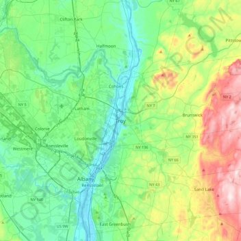
Nome: Mappa topografica Troy, altitudine, rilievo.
Luogo: Troy, Rensselaer County, New York, 12181, United States (42.56841 -73.85179 42.88841 -73.53179)
Altitudine media: 137 m
Altitudine minima: -2 m
Altitudine massima: 508 m
Fai una donazione
Preparati per la tua prossima avventura:
In qualità di associato Amazon, questo sito riceve una commissione sugli acquisti idonei senza alcun costo aggiuntivo per te.
Altre mappe topografiche
Clicca su una mappa per visualizzarne la topografia, l'altitudine e il rilievo.
East Greenbush CDP
United States > New York > Rensselaer County > Town of East Greenbush
The western section of the town along the Hudson River is marked by bluffs that rise to an elevation of between 100 and 300 feet. The little flat land that exists along the river is on the Papscanee Island. Papscanee Island is actually a peninsula, separated from the rest of the town by the Papscanee Creek.…
Altitudine media: 96 m
Town of East Greenbush
United States > New York > Rensselaer County
The western section of the town, along the Hudson River is marked by bluffs that rise to an elevation of between 100 and 300 feet. The little flat land that exists along the river is on the Papscanee Island. Papscanee Island is actually a peninsula, separated from the rest of the town by the Papscanee Creek.…
Altitudine media: 89 m
Fai una donazione
Preparati per la tua prossima avventura:
In qualità di associato Amazon, questo sito riceve una commissione sugli acquisti idonei senza alcun costo aggiuntivo per te.
Walloomsac Dam
United States > New York > Rensselaer County > Town of Hoosick > Walloomsac
Altitudine media: 191 m
Fai una donazione
Preparati per la tua prossima avventura:
In qualità di associato Amazon, questo sito riceve una commissione sugli acquisti idonei senza alcun costo aggiuntivo per te.
Fai una donazione
Preparati per la tua prossima avventura:
In qualità di associato Amazon, questo sito riceve una commissione sugli acquisti idonei senza alcun costo aggiuntivo per te.