
Fai una donazione
Preparati per la tua prossima avventura:
In qualità di associato Amazon, questo sito riceve una commissione sugli acquisti idonei senza alcun costo aggiuntivo per te.
Mappa topografica Wareham
Clicca sulla mappa per visualizzare l'altitudine.
Fai una donazione
Preparati per la tua prossima avventura:
In qualità di associato Amazon, questo sito riceve una commissione sugli acquisti idonei senza alcun costo aggiuntivo per te.
Wareham
Wareham was first settled in 1678 by Europeans as part of the towns of Plymouth and Rochester. It was officially incorporated in 1739 and named after the town of Wareham in England. Because of its geography, Wareham's early industry revolved around shipbuilding and the related industries. It also served as a resort town, with many smaller resorts scattered around the town, especially in Onset. Like Sandwich, its waterways, especially Buttermilk Bay, were considered as possible pathways for the Cape Cod Canal. Although the canal proper goes through Bourne and Sandwich, the southern approach to Buzzards Bay passes just south of the peninsulas that make up the topography of the town.
Fai una donazione
Preparati per la tua prossima avventura:
In qualità di associato Amazon, questo sito riceve una commissione sugli acquisti idonei senza alcun costo aggiuntivo per te.
A proposito di questa mappa
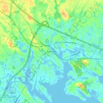
Nome: Mappa topografica Wareham, altitudine, rilievo.
Altitudine media: 10 m
Altitudine minima: -9 m
Altitudine massima: 37 m
Fai una donazione
Preparati per la tua prossima avventura:
In qualità di associato Amazon, questo sito riceve una commissione sugli acquisti idonei senza alcun costo aggiuntivo per te.