
Mappa topografica Gatineau
Clicca sulla mappa per visualizzare l'altitudine.
Gatineau
Gatineau is located in southwestern Quebec, on the northern bank of the Gatineau River. It is situated at an elevation of around 50 m (164.042 ft) The Gatineau Hills are the foothills of the Laurentian Mountains and located in the region. It is also the location of the second largest urban park in the world. They supply great skiing and snowboarding opportunities within minutes of the city. Gatineau is situated close to where the Canadian shield and the Saint Lawrence Lowlands intersect. The area has several major fault lines and small earthquakes do occur somewhat regularly, on average, there are at least one earthquake of intensity III or higher once every three years in Ottawa-Gatineau. The most memorable being the 2010 Central Canada earthquake that occurred in Quebec. The epicentre was situated approximately 56 kilometres (35 mi) north of Ottawa, Ontario, in the municipality of Val-des-Bois, Quebec.
A proposito di questa mappa
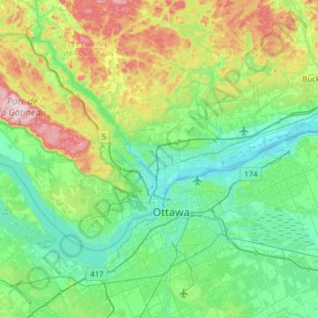
Nome: Mappa topografica Gatineau, altitudine, rilievo.
Luogo: Gatineau, Outaouais, Quebec, Canada (45.37238 -75.90835 45.59912 -75.34423)
Altitudine media: 127 m
Altitudine minima: 39 m
Altitudine massima: 409 m
Altre mappe topografiche
Clicca su una mappa per visualizzarne la topografia, l'altitudine e il rilievo.
Gault Nature Reserve
Canada > Quebec > La Vallée-du-Richelieu > Mont-Saint-Hilaire
Altitudine media: 189 m
Mount Royal
Canada > Quebec > Urban agglomeration of Montreal > Montreal
The hill is part of the Monteregian Hills situated between the Laurentians and the Appalachian Mountains. It gave its Latin name, Mons Regius, to the Monteregian chain. The hill consists of three peaks: Colline de la Croix (or Mont Royal proper) at 233 m (764 ft), Colline d'Outremont (or Mount Murray, in the…
Altitudine media: 111 m
Saint-Louis-de-Masham
Canada > Quebec > Les Collines-de-l'Outaouais > La Pêche
Altitudine media: 186 m
Magdalen Islands
Canada > Quebec > Urban agglomeration of Les Îles-de-la-Madeleine
Altitudine media: 1 m
Saint Helen's Island
Canada > Quebec > Urban agglomeration of Montreal > Montreal
Altitudine media: 15 m
Scouts Canada - Lake Lovering Scouts Reserve
Canada > Quebec > Memphrémagog > Magog
Altitudine media: 260 m
Madeleine-Centre
Canada > Quebec > La Haute-Gaspésie > Sainte-Madeleine-de-la-Rivière-Madeleine
Altitudine media: 72 m
Forêt Montmorency
Canada > Quebec > La Côte-de-Beaupré > Lac-Jacques-Cartier
Located in the Laurentian Mountains, the Montmorency forest is drained by the Montmorency River and by one of its tributaries, the Black river. There are four lakes: Lac Piché, Bédard, Laflamme and Joncas. The altitude varies between 600 and 1,000 meters (3,300 ft) with an average of 750 meters. The…
Altitudine media: 794 m
Mount Royal Park
Canada > Quebec > Urban agglomeration of Montreal > Montreal
The mountain is part of the Monteregian Hills situated between the Laurentians and the Appalachian Mountains. It gave its Latin name, Mons Regius, to the Monteregian chain. The mountain consists of three peaks: Colline de la Croix (or Mont Royal proper) at 233 m (764 ft), Colline d'Outremont (or Mount Murray,…
Altitudine media: 110 m
Cap-aux-Meules
Canada > Quebec > Urban agglomeration of Les Îles-de-la-Madeleine > Les Îles-de-la-Madeleine
Altitudine media: 13 m
Quebec
Canada > Quebec > Urban agglomeration of Québec
Quebec City was built on the north bank of the Saint Lawrence River, where it narrows and meets the mouth of the Saint-Charles River. Old Quebec is located on top and at the foot of Cap-Diamant, which is on the eastern edge of a plateau called the promontory of Quebec (Quebec hill). Because of this topographic…
Altitudine media: 100 m
Lac Saint-Thomas
Canada > Quebec > La Jacques-Cartier > Stoneham-et-Tewkesbury
Altitudine media: 505 m
Chisasibi (partie Inuit)
Canada > Quebec > Jamésie > Chisasibi (Land) > Chisasibi
Altitudine media: 11 m