
Fai una donazione
Preparati per la tua prossima avventura:
In qualità di associato Amazon, questo sito riceve una commissione sugli acquisti idonei senza alcun costo aggiuntivo per te.
Mappa topografica Alt-Ossiach
Clicca sulla mappa per visualizzare l'altitudine.
Fai una donazione
Preparati per la tua prossima avventura:
In qualità di associato Amazon, questo sito riceve una commissione sugli acquisti idonei senza alcun costo aggiuntivo per te.
A proposito di questa mappa
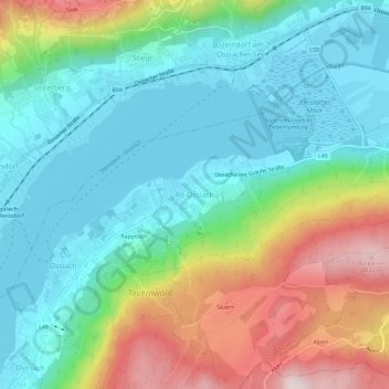
Nome: Mappa topografica Alt-Ossiach, altitudine, rilievo.
Altitudine media: 665 m
Altitudine minima: 495 m
Altitudine massima: 1.049 m
Fai una donazione
Preparati per la tua prossima avventura:
In qualità di associato Amazon, questo sito riceve una commissione sugli acquisti idonei senza alcun costo aggiuntivo per te.
Altre mappe topografiche
Clicca su una mappa per visualizzarne la topografia, l'altitudine e il rilievo.
Pasterze
Austria > Carinthia > Bezirk Spittal an der Drau > Heiligenblut am Großglockner
Altitudine media: 2.599 m
Fai una donazione
Preparati per la tua prossima avventura:
In qualità di associato Amazon, questo sito riceve una commissione sugli acquisti idonei senza alcun costo aggiuntivo per te.
Millstatt am See
Austria > Carinthia > Bezirk Spittal an der Drau
It is situated on the southern slope of the Gurktal Alps (Nock Mountains), on an alluvial fan peninsula on the lake's northern shore. The municipal area reaches from an elevation of 588 m (1,929 ft) at the lakeside to 2,101 m (6,893 ft) AA at the crest of the Millstätter Alpe massif. It comprises the…
Altitudine media: 1.149 m
Fai una donazione
Preparati per la tua prossima avventura:
In qualità di associato Amazon, questo sito riceve una commissione sugli acquisti idonei senza alcun costo aggiuntivo per te.
Lake Wörth
Austria > Carinthia > Bezirk Klagenfurt-Land > Schiefling am Wörthersee
Altitudine media: 619 m
Fai una donazione
Preparati per la tua prossima avventura:
In qualità di associato Amazon, questo sito riceve una commissione sugli acquisti idonei senza alcun costo aggiuntivo per te.
Fai una donazione
Preparati per la tua prossima avventura:
In qualità di associato Amazon, questo sito riceve una commissione sugli acquisti idonei senza alcun costo aggiuntivo per te.
Dellach
Austria > Carinthia > Bezirk Hermagor
The municipal area lies in the upper Gail valley, between the neighbouring municipalities of Kötschach-Mauthen in the west and Kirchbach in the east. The Carnic Alps in the south form the border with Paularo in Italy. In the north rises Mt. Reißkofel, the highest peak of the Gailtal Alps east of the Lienz…
Altitudine media: 1.233 m
Fai una donazione
Preparati per la tua prossima avventura:
In qualità di associato Amazon, questo sito riceve una commissione sugli acquisti idonei senza alcun costo aggiuntivo per te.
Lake Faak
Austria > Carinthia > Bezirk Villach-Land > Finkenstein am Faaker See > Faak am See
Altitudine media: 572 m
Fai una donazione
Preparati per la tua prossima avventura:
In qualità di associato Amazon, questo sito riceve una commissione sugli acquisti idonei senza alcun costo aggiuntivo per te.
Lake Pressegg
Austria > Carinthia > Bezirk Hermagor > Hermagor-Pressegger See > Presseggersee > Paßriach
Altitudine media: 627 m
Bad Kleinkirchheim
Austria > Carinthia > Bezirk Spittal an der Drau
Bad Kleinkirchheim is at an average elevation of 1,087 m (3,566 ft) in a 5 km (3 mi) stretch of a glacial trough valley in the Gurktal Alps (Nock Mountains), between the Millstätter See and the upper Gurk River. The populated section lies between 980 m (3,215 ft) and 1,380 m (4,528 ft), and the highest point…
Altitudine media: 1.605 m
Fai una donazione
Preparati per la tua prossima avventura:
In qualità di associato Amazon, questo sito riceve una commissione sugli acquisti idonei senza alcun costo aggiuntivo per te.
Fai una donazione
Preparati per la tua prossima avventura:
In qualità di associato Amazon, questo sito riceve una commissione sugli acquisti idonei senza alcun costo aggiuntivo per te.
Fai una donazione
Preparati per la tua prossima avventura:
In qualità di associato Amazon, questo sito riceve una commissione sugli acquisti idonei senza alcun costo aggiuntivo per te.
Bad Kleinkirchheim
Austria > Carinthia > Bezirk Spittal an der Drau
Bad Kleinkirchheim is at an average elevation of 1,087 m (3,566 ft) in a 5 km (3 mi) stretch of a glacial trough valley in the Gurktal Alps (Nock Mountains), between the Millstätter See and the upper Gurk River. The populated section lies between 980 m (3,215 ft) and 1,380 m (4,528 ft), and the highest point…
Altitudine media: 1.605 m
Lavamünd
Austria > Carinthia > Bezirk Wolfsberg
Lavamünd lies in the southeast of Carinthia, close to the border with Slovenia (Slovene Carinthia). It is situated at the confluence of the Lavant and Drava rivers. In the northeast, the Soboth Pass leads across the Koralpe range to Eibiswald in Styria. At an elevation of 348 m (1,142 ft) AA, the area is the…
Altitudine media: 768 m
Heiligenblut am Großglockner
Austria > Carinthia > Bezirk Spittal an der Drau
Altitudine media: 2.236 m
Fai una donazione
Preparati per la tua prossima avventura:
In qualità di associato Amazon, questo sito riceve una commissione sugli acquisti idonei senza alcun costo aggiuntivo per te.
Fai una donazione
Preparati per la tua prossima avventura:
In qualità di associato Amazon, questo sito riceve una commissione sugli acquisti idonei senza alcun costo aggiuntivo per te.
High Tauern National Park
Austria > Carinthia > Bezirk Spittal an der Drau > Heiligenblut am Großglockner
Altitudine media: 1.710 m
Fai una donazione
Preparati per la tua prossima avventura:
In qualità di associato Amazon, questo sito riceve una commissione sugli acquisti idonei senza alcun costo aggiuntivo per te.
Friesach
Austria > Carinthia > Bezirk Sankt Veit an der Glan
Friesach covers an area of 120.83 km2 and its mean elevation is 631 meters above sea level. It is located in northern Carinthia near the border with Styria, about 40 km (25 mi) north of its capital Klagenfurt.
Altitudine media: 1.044 m
Fai una donazione
Preparati per la tua prossima avventura:
In qualità di associato Amazon, questo sito riceve una commissione sugli acquisti idonei senza alcun costo aggiuntivo per te.
Nötsch im Gailtal
Austria > Carinthia > Bezirk Villach-Land > Nötsch im Gailtal
Altitudine media: 966 m
Maltatal
Austria > Carinthia > Bezirk Spittal an der Drau > Gmünd in Kärnten
Altitudine media: 1.914 m
Fai una donazione
Preparati per la tua prossima avventura:
In qualità di associato Amazon, questo sito riceve una commissione sugli acquisti idonei senza alcun costo aggiuntivo per te.