
Fai una donazione
Preparati per la tua prossima avventura:
In qualità di associato Amazon, questo sito riceve una commissione sugli acquisti idonei senza alcun costo aggiuntivo per te.
Mappa topografica Obervellach
Clicca sulla mappa per visualizzare l'altitudine.
Fai una donazione
Preparati per la tua prossima avventura:
In qualità di associato Amazon, questo sito riceve una commissione sugli acquisti idonei senza alcun costo aggiuntivo per te.
A proposito di questa mappa
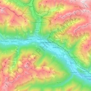
Nome: Mappa topografica Obervellach, altitudine, rilievo.
Altitudine media: 1.640 m
Altitudine minima: 613 m
Altitudine massima: 3.043 m
Fai una donazione
Preparati per la tua prossima avventura:
In qualità di associato Amazon, questo sito riceve una commissione sugli acquisti idonei senza alcun costo aggiuntivo per te.
Altre mappe topografiche
Clicca su una mappa per visualizzarne la topografia, l'altitudine e il rilievo.
Großglockner
Austria > Carinthia > Bezirk Spittal an der Drau > Heiligenblut am Großglockner
The Glockner is the highest mountain in the Alps east of the Ortler range, about 175 km (109 mi) away, and, after Mont Blanc, has the second greatest topographic isolation of all mountains in the Alps. Even its topographic prominence, at 2,424 m (7,953 ft), is the second highest after Mont Blanc in the entire…
Altitudine media: 3.128 m
Freier Seezugang Millstätter See bei Spittal an der Drau, Großegg
Austria > Carinthia > Bezirk Spittal an der Drau > Spittal an der Drau
Altitudine media: 677 m
Pasterze
Austria > Carinthia > Bezirk Spittal an der Drau > Heiligenblut am Großglockner
Altitudine media: 2.599 m
Sankt Wolfgang
Austria > Carinthia > Bezirk Spittal an der Drau > Seeboden am Millstätter See > Seebach
Altitudine media: 626 m
Fai una donazione
Preparati per la tua prossima avventura:
In qualità di associato Amazon, questo sito riceve una commissione sugli acquisti idonei senza alcun costo aggiuntivo per te.
Untertauern
Austria > Carinthia > Bezirk Spittal an der Drau > Heiligenblut am Großglockner
Altitudine media: 1.682 m
Großglockner
Austria > Carinthia > Bezirk Spittal an der Drau > Heiligenblut am Großglockner
The Glockner is the highest mountain in the Alps east of the Ortler range, about 175 km (109 mi) away, and, after Mont Blanc, has the second greatest topographic isolation of all mountains in the Alps. Even its topographic prominence, at 2,424 m (7,953 ft), is the second highest after Mont Blanc in the entire…
Altitudine media: 3.128 m
Fai una donazione
Preparati per la tua prossima avventura:
In qualità di associato Amazon, questo sito riceve una commissione sugli acquisti idonei senza alcun costo aggiuntivo per te.
Fai una donazione
Preparati per la tua prossima avventura:
In qualità di associato Amazon, questo sito riceve una commissione sugli acquisti idonei senza alcun costo aggiuntivo per te.
Tangern
Austria > Carinthia > Bezirk Spittal an der Drau > Spittal an der Drau
Altitudine media: 691 m
Falkert
Austria > Carinthia > Bezirk Spittal an der Drau > Bad Kleinkirchheim
Altitudine media: 2.023 m
Großglockner
Austria > Carinthia > Bezirk Spittal an der Drau > Heiligenblut am Großglockner
The Glockner is the highest mountain in the Alps east of the Ortler range, about 175 km (109 mi) away, and, after Mont Blanc, has the second greatest topographic isolation of all mountains in the Alps. Even its topographic prominence, at 2,424 m (7,953 ft), is the second highest after Mont Blanc in the entire…
Altitudine media: 3.128 m
Fai una donazione
Preparati per la tua prossima avventura:
In qualità di associato Amazon, questo sito riceve una commissione sugli acquisti idonei senza alcun costo aggiuntivo per te.
Großglockner
Austria > Carinthia > Bezirk Spittal an der Drau > Heiligenblut am Großglockner
The Glockner is the highest mountain in the Alps east of the Ortler range, about 175 km (109 mi) away, and, after Mont Blanc, has the second greatest topographic isolation of all mountains in the Alps. Even its topographic prominence, at 2,424 m (7,953 ft), is the second highest after Mont Blanc in the entire…
Altitudine media: 3.128 m
Rothorn
Austria > Carinthia > Bezirk Spittal an der Drau > Dellach im Drautal
Altitudine media: 2.299 m
Fai una donazione
Preparati per la tua prossima avventura:
In qualità di associato Amazon, questo sito riceve una commissione sugli acquisti idonei senza alcun costo aggiuntivo per te.
Heiligenblut
Austria > Carinthia > Bezirk Spittal an der Drau > Heiligenblut am Großglockner
Altitudine media: 1.982 m
Fai una donazione
Preparati per la tua prossima avventura:
In qualità di associato Amazon, questo sito riceve una commissione sugli acquisti idonei senza alcun costo aggiuntivo per te.
Maltatal
Austria > Carinthia > Bezirk Spittal an der Drau > Gmünd in Kärnten
Altitudine media: 1.914 m
Hadergasse
Austria > Carinthia > Bezirk Spittal an der Drau > Heiligenblut am Großglockner
Altitudine media: 1.677 m