
Mappa topografica Oxnard
Mappa interattiva
Clicca sulla mappa per visualizzare l'altitudine.
A proposito di questa mappa
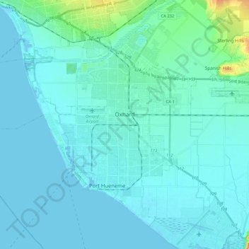
Nome: Mappa topografica Oxnard, altitudine, rilievo.
Luogo: Oxnard, Ventura County, California, United States (34.11932 -119.32922 34.26147 -119.11970)
Altitudine media: 16 m
Altitudine minima: -1 m
Altitudine massima: 179 m
Altre mappe topografiche
Clicca su una mappa per visualizzarne la topografia, l'altitudine e il rilievo.
Mount Pinos
United States > California > Ventura County
During and immediately after heavy snow storms it may not be possible to drive to the top of Mount Pinos Road due to the lack of snow plow availability. In such cases it is common for the Kern County Roads Department to close a snow gate lower on the mountain. It is still possible to ski from the snow gate and…
Altitudine media: 2.468 m
Newbury Park
United States > California > Ventura County > Thousand Oaks > Newbury Park
Newbury Park can be described as a town, community, or section mostly within the Thousand Oaks city limits in addition to rural areas west of Thousand Oaks. Newbury Park is bordered by Lynn Road in the east and the Conejo Grade on the west. It borders the Santa Monica Mountains in the south, while Hill Canyon…
Altitudine media: 262 m
Jasmine Glen Estates
United States > California > Ventura County > Simi Valley
Altitudine media: 331 m
Lake Piru
United States > California > Ventura County
The elevation of the reservoir is 1,043 ft (318 m), and the elevation of the dam spillway is 1,055 ft (322 m). The dam is owned and operated by the United Water Conservation District based in nearby Santa Paula, California. The district is a multi-service district providing flood control, recreation services,…
Altitudine media: 375 m
Casitas Springs
United States > California > Ventura County > Ventura > Casitas Springs
Altitudine media: 182 m
Greenwich Village
United States > California > Ventura County > Thousand Oaks > Greenwich Village
Altitudine media: 275 m
Johnson Creek Park
United States > California > Ventura County > Oxnard > Pleasant Valley Mobile Home Park
Altitudine media: 10 m