
Fai una donazione
Preparati per la tua prossima avventura:
In qualità di associato Amazon, questo sito riceve una commissione sugli acquisti idonei senza alcun costo aggiuntivo per te.
Mappa topografica Newbury Park
Clicca sulla mappa per visualizzare l'altitudine.
Fai una donazione
Preparati per la tua prossima avventura:
In qualità di associato Amazon, questo sito riceve una commissione sugli acquisti idonei senza alcun costo aggiuntivo per te.
Newbury Park
Newbury Park can be described as a town, community, or section mostly within the Thousand Oaks city limits in addition to rural areas west of Thousand Oaks. Newbury Park is bordered by Lynn Road in the east and the Conejo Grade on the west. It borders the Santa Monica Mountains in the south, while Hill Canyon and the ridges of Conejo Canyons Open Space make up its northernmost area. It has an average elevation of 628 feet (191 m) above sea level, and is situated 12 miles (19 km) from the Pacific Ocean. Newbury Park is 42 miles (68 km) west of Los Angeles. It is situated in the southeastern corner of Ventura County, between the Santa Monica Mountains to the south, and protected nature areas such as Wildwood Regional Park to the north. Thousand Oaks proper is to the east and the city of Camarillo is down the Conejo Grade to the west. Newbury Park is made up of ZIP code 91320; however, certain post office boxes by Newbury Road use ZIP code 91319.
Fai una donazione
Preparati per la tua prossima avventura:
In qualità di associato Amazon, questo sito riceve una commissione sugli acquisti idonei senza alcun costo aggiuntivo per te.
A proposito di questa mappa
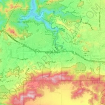
Nome: Mappa topografica Newbury Park, altitudine, rilievo.
Altitudine media: 262 m
Altitudine minima: 76 m
Altitudine massima: 509 m
Fai una donazione
Preparati per la tua prossima avventura:
In qualità di associato Amazon, questo sito riceve una commissione sugli acquisti idonei senza alcun costo aggiuntivo per te.