
Mappa topografica Haverhill
Mappa interattiva
Clicca sulla mappa per visualizzare l'altitudine.
Haverhill
According to the United States Census Bureau, the city has a total area of 35.6 square miles (92.3 km2), of which 33.0 square miles (85.4 km2) is land and 2.7 square miles (6.9 km2), or 7.47%, is water. The city ranks 60th in the Commonwealth in terms of land area, and is the largest city or town in Essex County. Haverhill is drained by the Little and Merrimack rivers, the latter separating the Bradford section of town from the rest of Haverhill. The highest point in the city is found on Ayers Hill, a drumlin with two knobs of almost equal elevation of at least 335 feet (102 m), according to the most recent (2011-2012) USGS 7.5-minute topographical map. The city also has several ponds and lakes, as well as three golf courses.
A proposito di questa mappa
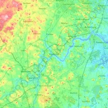
Nome: Mappa topografica Haverhill, altitudine, rilievo.
Luogo: Haverhill, Essex County, Massachusetts, 01830, United States (42.61778 -71.23677 42.93778 -70.91677)
Altitudine media: 45 m
Altitudine minima: -5 m
Altitudine massima: 178 m
Altre mappe topografiche
Clicca su una mappa per visualizzarne la topografia, l'altitudine e il rilievo.