
Fai una donazione
Preparati per la tua prossima avventura:
In qualità di associato Amazon, questo sito riceve una commissione sugli acquisti idonei senza alcun costo aggiuntivo per te.
Mappa topografica Arlington
Clicca sulla mappa per visualizzare l'altitudine.
Fai una donazione
Preparati per la tua prossima avventura:
In qualità di associato Amazon, questo sito riceve una commissione sugli acquisti idonei senza alcun costo aggiuntivo per te.
Arlington
Arlington lies in the Valley of Vermont between the Taconic Range to the west and the Green Mountains to the east, with most of Arlington's land mass lying in the Taconic Range. Five prominent peaks are located within the town: Grass Mountain, Spruce Peak, The Ball (also locally referred to as West Mountain), Red Mountain, and Big Spruce Mountain. The highest peak is Grass Mountain at elevation 3,109 ft (948 m).
Fai una donazione
Preparati per la tua prossima avventura:
In qualità di associato Amazon, questo sito riceve una commissione sugli acquisti idonei senza alcun costo aggiuntivo per te.
A proposito di questa mappa
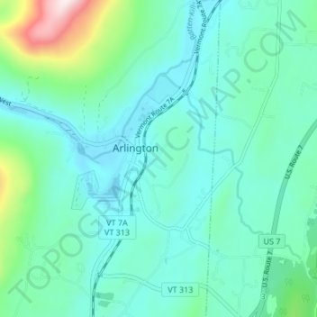
Nome: Mappa topografica Arlington, altitudine, rilievo.
Luogo: Arlington, Bennington County, Vermont, United States (43.04866 -73.16635 43.09792 -73.11899)
Altitudine media: 282 m
Altitudine minima: 175 m
Altitudine massima: 768 m
Fai una donazione
Preparati per la tua prossima avventura:
In qualità di associato Amazon, questo sito riceve una commissione sugli acquisti idonei senza alcun costo aggiuntivo per te.