
Mappa topografica Hardoi
Clicca sulla mappa per visualizzare l'altitudine.
Hardoi
Hardoi is located at 27°25′N 80°07′E / 27.42°N 80.12°E / 27.42; 80.12. It has an average elevation of 134 metres (440 ft). Hardoi is located 110 km from Lucknow (capital of Uttar Pradesh) and 394 from New Delhi (capital of India). The Ganges and several of its tributaries are crossing the south of Hardoi district. Its area is 5947 square kilometres. The record height is 500 ft. In 1995, Hardoi district had 5 square kilometres of dense forest and 13 square kilometres of open forest. The length of this district from northwest to southeast is 125.529 km and width from east to west are 74.83 km. District Hardoi comprises five tehsils (Hardoi, Shahabad, Bilgram, Sandila, and Sawayajpur), 19 blocks, 191 Nyay Panchayat, 1101 Gram Sabha, and 1901 inhabited revenue villages. Sandi Bird Sanctuary created in 1990, previously, "Dahar Jheel", is an important ecotourism bird habitat. Gomati river flows mainly in Hardoi.
A proposito di questa mappa
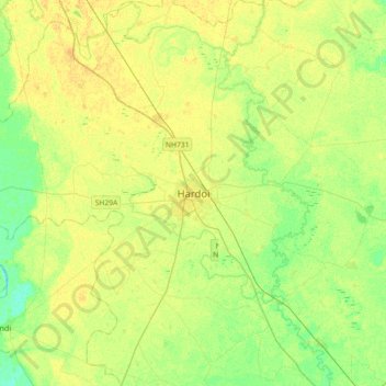
Nome: Mappa topografica Hardoi, altitudine, rilievo.
Luogo: Hardoi, Hardoi District, Uttar Pradesh, 241001, India (27.24106 79.97297 27.56106 80.29297)
Altitudine media: 141 m
Altitudine minima: 130 m
Altitudine massima: 149 m