
Mappa topografica Ribeira da Janela
Mappa interattiva
Clicca sulla mappa per visualizzare l'altitudine.
A proposito di questa mappa
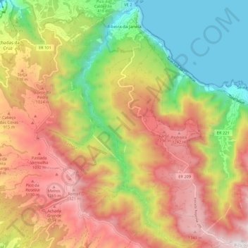
Nome: Mappa topografica Ribeira da Janela, altitudine, rilievo.
Luogo: Ribeira da Janela, Porto Moniz, Madeira, 9270, Portugal (32.76715 -17.17608 32.85736 -17.10635)
Altitudine media: 713 m
Altitudine minima: -1 m
Altitudine massima: 1.461 m
It is located northeast coast of the municipality of Porto Moniz, connected by the main roadway that circles the island to the principal communities in Funchal and Calheta. Mountainous, the parish is cut by several river valleys extending into the Atlantic Ocean from the interior plateau of Paul da Serra, where it borders the municipalities of Ponta do Sol and Calheta. The ravine, Ribeira da Janela, meanders through the parish from Paul da Serra (springing from the plateau at around 1,420 metres altitude) and flows at various intervals along the water course. The valley cut by this ravine is one of the longest in Madeira. Forests dominate the northern and the western parts of the valley and while brush characterises the remaining areas.
Altre mappe topografiche
Clicca su una mappa per visualizzarne la topografia, l'altitudine e il rilievo.