
Mappa topografica Park Hill
Mappa interattiva
Clicca sulla mappa per visualizzare l'altitudine.
A proposito di questa mappa
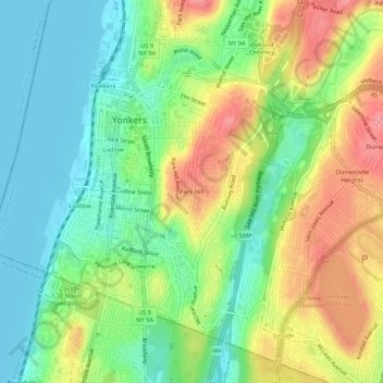
Nome: Mappa topografica Park Hill, altitudine, rilievo.
Altitudine media: 43 m
Altitudine minima: 0 m
Altitudine massima: 106 m
Altre mappe topografiche
Clicca su una mappa per visualizzarne la topografia, l'altitudine e il rilievo.
Cecil Park
United States > New York > Westchester County > City of Yonkers
Cecil Park, City of Yonkers, Westchester County, New York, 10707, United States
Altitudine media: 70 m
Colonial Heights
United States > New York > Westchester County > City of Yonkers
Colonial Heights, City of Yonkers, Westchester County, New York, 10710, United States
Altitudine media: 60 m
Grey Oaks
United States > New York > Westchester County > City of Yonkers
Grey Oaks, City of Yonkers, Westchester County, New York, 10703, United States
Altitudine media: 60 m
Lowerre
United States > New York > Westchester County > City of Yonkers
Lowerre, City of Yonkers, Westchester County, New York, 10705, United States
Altitudine media: 34 m
Crestwood Gardens
United States > New York > Westchester County > City of Yonkers
Crestwood Gardens, City of Yonkers, Westchester County, New York, 10707, United States
Altitudine media: 65 m
Gunther Park
United States > New York > Westchester County > City of Yonkers
Gunther Park, City of Yonkers, Westchester County, New York, 10704, United States
Altitudine media: 56 m
Bronxville Heights
United States > New York > Westchester County > City of Yonkers
Bronxville Heights, City of Yonkers, Westchester County, New York, 10710, United States
Altitudine media: 63 m
Nepperhan
United States > New York > Westchester County > City of Yonkers
Nepperhan, City of Yonkers, Westchester County, New York, 10703, United States
Altitudine media: 64 m