
Fai una donazione
Preparati per la tua prossima avventura:
In qualità di associato Amazon, questo sito riceve una commissione sugli acquisti idonei senza alcun costo aggiuntivo per te.
Mappa topografica Rügen
Clicca sulla mappa per visualizzare l'altitudine.
Fai una donazione
Preparati per la tua prossima avventura:
In qualità di associato Amazon, questo sito riceve una commissione sugli acquisti idonei senza alcun costo aggiuntivo per te.
Rügen
Rügen has a total area of 926.4 km2 (357.7 sq mi), or 974 km2 (376 sq mi) if the adjacent small islands are included. The maximum diameter is 51.4 km (31.9 mi) from north to south, and 42.8 km (26.6 mi) from east to west. Of an overall 574 km (357 mi)-long coastline, 56 km (35 mi) are sandy Baltic Sea beaches, and 2.8 km (1.7 mi) sandy bodden beaches. The highest elevations are on the Jasmund peninsula: Piekberg (161 m (528 ft)) and Königsstuhl (117 m (384 ft)).
Fai una donazione
Preparati per la tua prossima avventura:
In qualità di associato Amazon, questo sito riceve una commissione sugli acquisti idonei senza alcun costo aggiuntivo per te.
A proposito di questa mappa
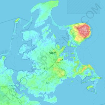
Nome: Mappa topografica Rügen, altitudine, rilievo.
Luogo: Rügen, Mecklenburg-Vorpommern, Germany (54.22068 13.11401 54.68508 13.76652)
Altitudine media: 7 m
Altitudine minima: -5 m
Altitudine massima: 163 m
Fai una donazione
Preparati per la tua prossima avventura:
In qualità di associato Amazon, questo sito riceve una commissione sugli acquisti idonei senza alcun costo aggiuntivo per te.
Altre mappe topografiche
Clicca su una mappa per visualizzarne la topografia, l'altitudine e il rilievo.
Fai una donazione
Preparati per la tua prossima avventura:
In qualità di associato Amazon, questo sito riceve una commissione sugli acquisti idonei senza alcun costo aggiuntivo per te.
Fai una donazione
Preparati per la tua prossima avventura:
In qualità di associato Amazon, questo sito riceve una commissione sugli acquisti idonei senza alcun costo aggiuntivo per te.
Fai una donazione
Preparati per la tua prossima avventura:
In qualità di associato Amazon, questo sito riceve una commissione sugli acquisti idonei senza alcun costo aggiuntivo per te.
Riemserort
Germany > Mecklenburg-Vorpommern > Vorpommern-Greifswald > Greifswald
Altitudine media: 1 m
Bohnenwerder
Germany > Mecklenburg-Vorpommern > Mecklenburgische Seenplatte > Carwitz
Altitudine media: 91 m
Fai una donazione
Preparati per la tua prossima avventura:
In qualità di associato Amazon, questo sito riceve una commissione sugli acquisti idonei senza alcun costo aggiuntivo per te.
Valluhn
Germany > Mecklenburg-Vorpommern > Ludwigslust-Parchim > Lüttow-Valluhn
Altitudine media: 32 m
Greifswald
Germany > Mecklenburg-Vorpommern > Vorpommern-Greifswald > Greifswald > Greifswald
Altitudine media: 6 m
Fai una donazione
Preparati per la tua prossima avventura:
In qualità di associato Amazon, questo sito riceve una commissione sugli acquisti idonei senza alcun costo aggiuntivo per te.
Wismar
Germany > Mecklenburg-Vorpommern > Nordwestmecklenburg > Wismar > Wismar
Altitudine media: 14 m
Löcknitz
Germany > Mecklenburg-Vorpommern > Vorpommern-Greifswald > Löcknitz > Löcknitz
Altitudine media: 13 m
Fai una donazione
Preparati per la tua prossima avventura:
In qualità di associato Amazon, questo sito riceve una commissione sugli acquisti idonei senza alcun costo aggiuntivo per te.
Bismark
Germany > Mecklenburg-Vorpommern > Vorpommern-Greifswald > Ramin > Bismark
Altitudine media: 36 m