
Fai una donazione
Preparati per la tua prossima avventura:
In qualità di associato Amazon, questo sito riceve una commissione sugli acquisti idonei senza alcun costo aggiuntivo per te.
Mappa topografica Connersville
Clicca sulla mappa per visualizzare l'altitudine.
Fai una donazione
Preparati per la tua prossima avventura:
In qualità di associato Amazon, questo sito riceve una commissione sugli acquisti idonei senza alcun costo aggiuntivo per te.
Connersville
Most of the town is located on the north bank of the west fork of the Whitewater River. The town is at modest elevation, a little over 800 feet (240 m) above sea level. The local area has nearly flat to gently rolling topography. The local region (and all of Fayette County and the state of Indiana) are part of the Eastern (U.S.) Broadleaf Forest Environment biome. Much of the surrounding Whitewater Valley vegetation would be classified as riparian woodland or gallery forest. There are 124 native tree species, including 17 varieties of oak, as well as black walnut, sycamore, and tulip tree (yellow poplar), the state tree. Fruit trees—apple, cherry, peach, and pear—are common. Common native mammals are the red fox, common cottontail, muskrat, raccoon, opossum, and several types of squirrel.
Fai una donazione
Preparati per la tua prossima avventura:
In qualità di associato Amazon, questo sito riceve una commissione sugli acquisti idonei senza alcun costo aggiuntivo per te.
A proposito di questa mappa
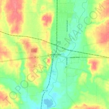
Nome: Mappa topografica Connersville, altitudine, rilievo.
Luogo: Connersville, Fayette County, Indiana, 47331, United States (39.60116 -85.18107 39.68116 -85.10107)
Altitudine media: 269 m
Altitudine minima: 236 m
Altitudine massima: 313 m
Fai una donazione
Preparati per la tua prossima avventura:
In qualità di associato Amazon, questo sito riceve una commissione sugli acquisti idonei senza alcun costo aggiuntivo per te.