
Fai una donazione
Preparati per la tua prossima avventura:
In qualità di associato Amazon, questo sito riceve una commissione sugli acquisti idonei senza alcun costo aggiuntivo per te.
Mappa topografica Squaw Valley
Clicca sulla mappa per visualizzare l'altitudine.
Fai una donazione
Preparati per la tua prossima avventura:
In qualità di associato Amazon, questo sito riceve una commissione sugli acquisti idonei senza alcun costo aggiuntivo per te.
Squaw Valley
Squaw Valley (formerly, Squawvalley) is a census-designated place located in Fresno County, California, in the United States. As of the 2010 census, the CDP had a total population of 3,162, up from 2,691 at the 2000 census. Despite the similar name, it is not the location of Squaw Valley Ski Resort or the 1960 Winter Olympics. Squaw Valley is located 9 miles (14 km) north-northeast of Orange Cove and 30 miles (48 km) east of Fresno, at an elevation of 1,631 ft (497 m). The name is controversial because squaw is an ethnic and sexual slur, historically used for indigenous North American women.
Fai una donazione
Preparati per la tua prossima avventura:
In qualità di associato Amazon, questo sito riceve una commissione sugli acquisti idonei senza alcun costo aggiuntivo per te.
A proposito di questa mappa
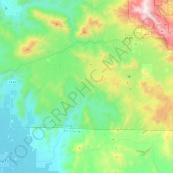
Nome: Mappa topografica Squaw Valley, altitudine, rilievo.
Luogo: Squaw Valley, Fresno County, California, United States (36.65755 -119.30466 36.75426 -119.06844)
Altitudine media: 557 m
Altitudine minima: 128 m
Altitudine massima: 1.624 m
Fai una donazione
Preparati per la tua prossima avventura:
In qualità di associato Amazon, questo sito riceve una commissione sugli acquisti idonei senza alcun costo aggiuntivo per te.