
Mappa topografica Jamestown
Mappa interattiva
Clicca sulla mappa per visualizzare l'altitudine.
A proposito di questa mappa
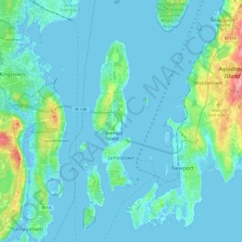
Nome: Mappa topografica Jamestown, altitudine, rilievo.
Altitudine media: 8 m
Altitudine minima: -5 m
Altitudine massima: 66 m
Altre mappe topografiche
Clicca su una mappa per visualizzarne la topografia, l'altitudine e il rilievo.
Portsmouth
United States > Rhode Island > Newport County
Portsmouth, Newport County, Rhode Island, United States
Altitudine media: 19 m
Fort Wetherill
United States > Rhode Island > Newport County > Jamestown
Fort Wetherill, Highland Drive, Jamestown, Newport County, Rhode Island, 02835, United States
Altitudine media: 4 m
Aquidneck Island
United States > Rhode Island > Newport County > Portsmouth
Aquidneck Island, Portsmouth, Newport County, Rhode Island, United States
Altitudine media: 13 m
Pocasset Hill
United States > Rhode Island > Newport County > Tiverton
Pocasset Hill, Tiverton, Newport County, Rhode Island, 02878, United States
Altitudine media: 51 m
Newport
United States > Rhode Island > Newport County
Newport, Newport County, Rhode Island, 02840, United States
Altitudine media: 8 m
Middletown
United States > Rhode Island > Newport County
Middletown, Newport County, Rhode Island, 02842, United States
Altitudine media: 19 m
Tiverton
United States > Rhode Island > Newport County
Tiverton, Newport County, Rhode Island, 02878, United States
Altitudine media: 31 m