
Fai una donazione
Preparati per la tua prossima avventura:
In qualità di associato Amazon, questo sito riceve una commissione sugli acquisti idonei senza alcun costo aggiuntivo per te.
Mappa topografica Pass Christian
Clicca sulla mappa per visualizzare l'altitudine.
Fai una donazione
Preparati per la tua prossima avventura:
In qualità di associato Amazon, questo sito riceve una commissione sugli acquisti idonei senza alcun costo aggiuntivo per te.
Pass Christian
On August 29, 2005, Pass Christian was almost completely destroyed by Hurricane Katrina. Of the approximately 8,000 homes in Pass Christian, all but 500 were damaged or destroyed. In spite of the fact that the beachfront Scenic Drive follows the crest of a small bluff, affording it some elevation, most of the historic mansions along the road were severely damaged, and many were completely destroyed, including the superbly restored Greek Revival mansion "Union Quarters" described in the National Register of Historic Places as having been built in 1855. A cast iron fence fronted the property enclosing a Magnolia Historical Marker which was dedicated in 1960. It read, "Union officers were temporarily quartered here during the invasion of Pass Christian."
Fai una donazione
Preparati per la tua prossima avventura:
In qualità di associato Amazon, questo sito riceve una commissione sugli acquisti idonei senza alcun costo aggiuntivo per te.
A proposito di questa mappa
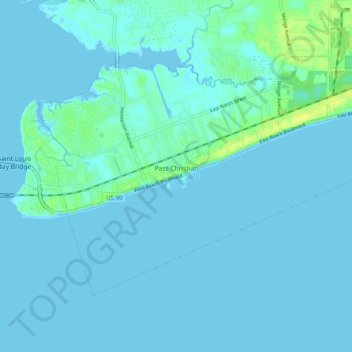
Nome: Mappa topografica Pass Christian, altitudine, rilievo.
Altitudine media: 2 m
Altitudine minima: -3 m
Altitudine massima: 14 m
Fai una donazione
Preparati per la tua prossima avventura:
In qualità di associato Amazon, questo sito riceve una commissione sugli acquisti idonei senza alcun costo aggiuntivo per te.