
Mappa topografica Thayne
Mappa interattiva
Clicca sulla mappa per visualizzare l'altitudine.
Thayne
Thayne is located at 42°55′11″N 111°0′3″W / 42.91972°N 111.00083°W / 42.91972; -111.00083 (42.919754, –111.000714), at 5906 feet in elevation. It sits in the northern portion of Wyoming's grassy Star Valley, close to the Salt River. Thayne is surrounded by green grassland and ranches, with forested mountains at the valley's edge.
A proposito di questa mappa
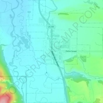
Nome: Mappa topografica Thayne, altitudine, rilievo.
Luogo: Thayne, Lincoln County, Wyoming, 83127, United States (42.90253 -111.01238 42.93177 -110.97281)
Altitudine media: 1.814 m
Altitudine minima: 1.783 m
Altitudine massima: 1.961 m
Altre mappe topografiche
Clicca su una mappa per visualizzarne la topografia, l'altitudine e il rilievo.