
Mappa topografica Freising
Mappa interattiva
Clicca sulla mappa per visualizzare l'altitudine.
A proposito di questa mappa
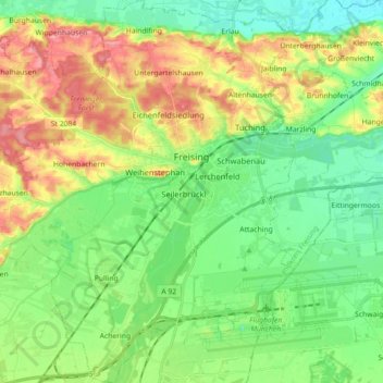
Nome: Mappa topografica Freising, altitudine, rilievo.
Luogo: Freising, Landkreis Freising, Bavaria, Germany (48.33061 11.64045 48.44903 11.79251)
Altitudine media: 457 m
Altitudine minima: 419 m
Altitudine massima: 522 m
In 1802/1803 Bavaria fell under the influence of Napoleonic France in which church controlled lands were secularized. In Freising, the more than thousand-year-old bishopric was abolished. The Roman Catholic Church lost most of its properties and authority over the city. Though the seat of the diocese was moved to Munich in 1821, including the elevation to an archdiocese, Freising has remained the seat of diocesan administration until today.
Altre mappe topografiche
Clicca su una mappa per visualizzarne la topografia, l'altitudine e il rilievo.
Neufahrn bei Freising
Germany > Bavaria > Landkreis Freising
Neufahrn bei Freising, Landkreis Freising, Bavaria, Germany
Altitudine media: 464 m
85413
Germany > Bavaria > Landkreis Freising > Margarethenried > Sixt in der Point
85413, Sixt in der Point, Margarethenried, Hörgertshausen, Mauern (VGem), Landkreis Freising, Bavaria, Germany
Altitudine media: 484 m
Dietersheim
Germany > Bavaria > Landkreis Freising
Dietersheim, Eching, Landkreis Freising, Bavaria, 85386, Germany
Altitudine media: 471 m
Günzenhausen
Germany > Bavaria > Landkreis Freising
Günzenhausen, Eching, Landkreis Freising, Bavaria, 85376, Germany
Altitudine media: 477 m
Mariabrunn
Germany > Bavaria > Landkreis Freising > Birkeneck
Mariabrunn, Birkeneck, Hallbergmoos, Landkreis Freising, Bavaria, 85399, Germany
Altitudine media: 453 m
Spörerau
Germany > Bavaria > Landkreis Freising > Wang
Spörerau, Wang, Mauern (VGem), Landkreis Freising, Bavaria, 84079, Germany
Altitudine media: 410 m
Moosburg
Germany > Bavaria > Landkreis Freising
Moosburg, Landkreis Freising, Bavaria, 85368, Germany
Altitudine media: 428 m