
Fai una donazione
Preparati per la tua prossima avventura:
In qualità di associato Amazon, questo sito riceve una commissione sugli acquisti idonei senza alcun costo aggiuntivo per te.
Mappa topografica Silver City
Clicca sulla mappa per visualizzare l'altitudine.
Fai una donazione
Preparati per la tua prossima avventura:
In qualità di associato Amazon, questo sito riceve una commissione sugli acquisti idonei senza alcun costo aggiuntivo per te.
Silver City
During the period from 1901 to 1964, when readings were taken at the city center (which is cooler and wetter than outlying and lower-elevation districts nearby), the coldest temperature recorded was −13 °F (−25 °C) on January 11, 1962, and the hottest 105 °F (40.6 °C) on July 5, 1901. The coldest month was January 1949, with a monthly mean temperature of 28.7 °F or −1.8 °C, and the hottest, July 1951, which averaged 77.4 °F or 25.2 °C. The wettest calendar year in this time span was 1914, with 24.97 inches or 634.2 millimetres and the driest, 1947 with 6.77 inches or 172.0 millimetres. The most snow in one season was 48.0 inches or 1.22 metres between July 1912 and June 1913, which featured the coldest winter on record with 33.1 °F or 0.6 °C as the mean from December to February.
Fai una donazione
Preparati per la tua prossima avventura:
In qualità di associato Amazon, questo sito riceve una commissione sugli acquisti idonei senza alcun costo aggiuntivo per te.
A proposito di questa mappa
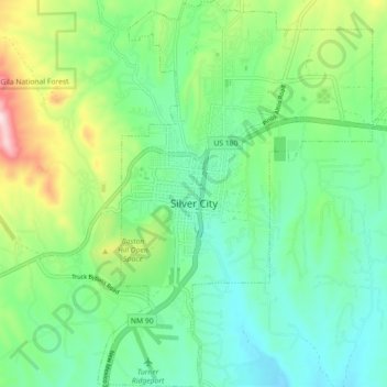
Nome: Mappa topografica Silver City, altitudine, rilievo.
Luogo: Silver City, Grant County, New Mexico, United States (32.73527 -108.29886 32.81071 -108.22398)
Altitudine media: 1.851 m
Altitudine minima: 1.733 m
Altitudine massima: 2.151 m
Fai una donazione
Preparati per la tua prossima avventura:
In qualità di associato Amazon, questo sito riceve una commissione sugli acquisti idonei senza alcun costo aggiuntivo per te.
Altre mappe topografiche
Clicca su una mappa per visualizzarne la topografia, l'altitudine e il rilievo.
Fai una donazione
Preparati per la tua prossima avventura:
In qualità di associato Amazon, questo sito riceve una commissione sugli acquisti idonei senza alcun costo aggiuntivo per te.
Basin and Range Country Historical Marker
United States > New Mexico > Grant County
Altitudine media: 1.393 m