Mappa topografica Boxford
Clicca sulla mappa per visualizzare l'altitudine.
Boxford
Boxford is divided into Boxford Village (commonly called East Boxford) and West Boxford Village, corresponding to the respective East and West Boxford centers. It is heavily forested and criss-crossed by various streams and brooks, many of which empty into the Ipswich River on Boxford's southern border. A number of ponds dot town as well, among them Stiles Pond, Cedar Pond, Spofford Pond, Lowe Pond, Four Mile Pond and Baldpate Pond. Throughout Boxford there are also a number of scenic hiking trails. The highest natural point in Boxford is Bald Hill, at an elevation of 243 feet (74 m). It sits in a corner of the Boxford State Forest, near Interstate 95 and the town's border with Middleton.
A proposito di questa mappa
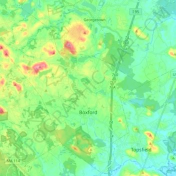
Nome: Mappa topografica Boxford, altitudine, rilievo.
Luogo: Boxford, Essex County, Massachusetts, 01921, United States (42.62068 -71.10863 42.73700 -70.94859)
Altitudine media: 35 m
Altitudine minima: 7 m
Altitudine massima: 105 m
Altre mappe topografiche
Clicca su una mappa per visualizzarne la topografia, l'altitudine e il rilievo.


Forest River Park
United States > Massachusetts > Essex County > Salem > South Salem
Altitudine media: 8 m





Browns Point
United States > Massachusetts > Essex County > Salisbury > Salisbury Beach
Altitudine media: 2 m


Little River Marshes
United States > Massachusetts > Essex County > Gloucester > West Gloucester
Altitudine media: 27 m

Freshwater Cove Village
United States > Massachusetts > Essex County > Gloucester
Altitudine media: 18 m

Blackwater River
United States > Massachusetts > Essex County > Salisbury > Salisbury Beach
Altitudine media: 4 m










Kettle Cove Village
United States > Massachusetts > Essex County > Manchester-by-the-Sea
Altitudine media: 18 m