
Mappa topografica Drumgeith Park
Mappa interattiva
Clicca sulla mappa per visualizzare l'altitudine.
A proposito di questa mappa
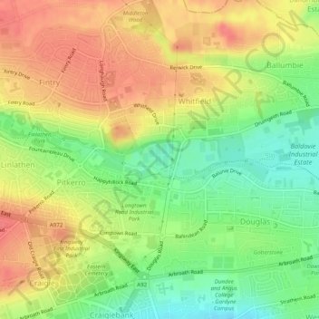
Nome: Mappa topografica Drumgeith Park, altitudine, rilievo.
Altitudine media: 54 m
Altitudine minima: 20 m
Altitudine massima: 83 m
Altre mappe topografiche
Clicca su una mappa per visualizzarne la topografia, l'altitudine e il rilievo.
Broughty Castle
United Kingdom > Scotland > Dundee City > Dundee
Broughty Castle, Castle Approach, Broughty Ferry, Dundee, Dundee City, Scotland, DD5 2TF, United Kingdom
Altitudine media: 10 m
Camperdown Country Park
United Kingdom > Scotland > Dundee City > Dundee
Camperdown Country Park, Dundee, Dundee City, Scotland, DD2 4TF, United Kingdom
Altitudine media: 120 m
Claypotts Castle
United Kingdom > Scotland > Dundee City > Dundee
Claypotts Castle, Claypotts Castle Gardens, Broughty Ferry, Dundee, Dundee City, Scotland, DD5 3JY, United Kingdom
Altitudine media: 28 m