
Mappa topografica Copley
Clicca sulla mappa per visualizzare l'altitudine.
A proposito di questa mappa
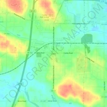
Nome: Mappa topografica Copley, altitudine, rilievo.
Altitudine media: 318 m
Altitudine minima: 297 m
Altitudine massima: 350 m
Altre mappe topografiche
Clicca su una mappa per visualizzarne la topografia, l'altitudine e il rilievo.
Akron
United States > Ohio > Summit County
Akron is situated within the Glaciated Allegheny Plateau, creating a rolling landscape with variable elevations. The city, which lies around 40 miles south of Lake Erie, has an average elevation of approximately 960 feet above sea level, though elevations range from about 700 feet along the Cuyahoga River…
Altitudine media: 315 m
Cuyahoga Valley National Park
United States > Ohio > Summit County > Cuyahoga Heights
Altitudine media: 313 m
Cuyahoga Valley National Park
United States > Ohio > Summit County > Cuyahoga Heights
Altitudine media: 313 m
Akron
United States > Ohio > Summit County
Akron is located in the Great Lakes region about 39 miles (63 km) south of Lake Erie, on the Glaciated Allegheny Plateau. It is bordered by Cuyahoga Falls on the north and Barberton in the southwest. It is the center of the Akron metropolitan area which covers Summit and Portage Counties, and a principal city…
Altitudine media: 315 m