
Fai una donazione
Preparati per la tua prossima avventura:
In qualità di associato Amazon, questo sito riceve una commissione sugli acquisti idonei senza alcun costo aggiuntivo per te.
Mappa topografica Cummingston
Clicca sulla mappa per visualizzare l'altitudine.
Fai una donazione
Preparati per la tua prossima avventura:
In qualità di associato Amazon, questo sito riceve una commissione sugli acquisti idonei senza alcun costo aggiuntivo per te.
Cummingston
The village sits approximately 150 metres south from the mainly rocky shore at an elevation of around 40 metres. The ground to the south is set in farmland and rises to around 60 metres, providing extensive views of the Moray coastline, the Moray Firth and the Highland region to the north. Separated to the west from Burghead by farmland and from Hopeman to the east by a closed landfill site and further farmland, the Moray Council Local Plan seeks to retain the village's present small linear nature by preventing housing construction in these areas. Part of the foreshore is designated a "Site of Special Scientific Interest."
Fai una donazione
Preparati per la tua prossima avventura:
In qualità di associato Amazon, questo sito riceve una commissione sugli acquisti idonei senza alcun costo aggiuntivo per te.
A proposito di questa mappa
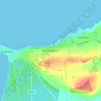
Nome: Mappa topografica Cummingston, altitudine, rilievo.
Luogo: Cummingston, Moray, Scotland, IV30 5XY, United Kingdom (57.68205 -3.47783 57.72205 -3.43783)
Altitudine media: 17 m
Altitudine minima: 0 m
Altitudine massima: 83 m
Fai una donazione
Preparati per la tua prossima avventura:
In qualità di associato Amazon, questo sito riceve una commissione sugli acquisti idonei senza alcun costo aggiuntivo per te.
Altre mappe topografiche
Clicca su una mappa per visualizzarne la topografia, l'altitudine e il rilievo.
Fochabers
United Kingdom > Scotland > Moray
The present village owes its existence to Alexander Gordon, 4th Duke of Gordon (1743–1827). During the late eighteenth century, during the Scottish Enlightenment, it was fashionable for landowners to found new towns and villages; these can be recognised all over Scotland, because unlike their predecessors…
Altitudine media: 59 m
Fai una donazione
Preparati per la tua prossima avventura:
In qualità di associato Amazon, questo sito riceve una commissione sugli acquisti idonei senza alcun costo aggiuntivo per te.
Fai una donazione
Preparati per la tua prossima avventura:
In qualità di associato Amazon, questo sito riceve una commissione sugli acquisti idonei senza alcun costo aggiuntivo per te.