
Fai una donazione
Preparati per la tua prossima avventura:
In qualità di associato Amazon, questo sito riceve una commissione sugli acquisti idonei senza alcun costo aggiuntivo per te.
Mappa topografica Flatwoods
Clicca sulla mappa per visualizzare l'altitudine.
Fai una donazione
Preparati per la tua prossima avventura:
In qualità di associato Amazon, questo sito riceve una commissione sugli acquisti idonei senza alcun costo aggiuntivo per te.
Flatwoods
The area now known as Flatwoods was originally named "Advance": Advance Methodist Church formed a Sunday school beginning in 1860. The name was later changed to "Cheap", after John Cheap, a blind clergyman. The original farming community returned to the name of "Advance" when a post office was established in 1918. In 1938, the post office was renamed "Flatwoods", and the town was incorporated the same year under that name. Flatwoods is named for the area's unique topography, a belt of flat wooded land in the ancient Teays River valley on an elevation of approximately 650 feet (200 m) or higher, just south of and 150 feet (46 m) higher than the Ohio River valley. The availability of flat level land and low tax rates made Flatwoods a local hot spot of new construction in the 1950s and 1960s, when many upper-middle-class tract housing developments were built and quickly inhabited. A main contributor to Flatwoods' growth was the fact that nearby Ashland had developed much of its available land prior to 1960, with little new construction possible within its corporation limits.
Fai una donazione
Preparati per la tua prossima avventura:
In qualità di associato Amazon, questo sito riceve una commissione sugli acquisti idonei senza alcun costo aggiuntivo per te.
A proposito di questa mappa
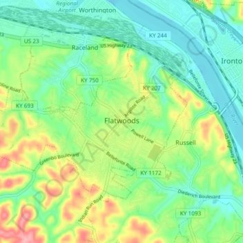
Nome: Mappa topografica Flatwoods, altitudine, rilievo.
Luogo: Flatwoods, Greenup County, Kentucky, United States (38.50385 -82.77101 38.54070 -82.69707)
Altitudine media: 194 m
Altitudine minima: 156 m
Altitudine massima: 270 m
Fai una donazione
Preparati per la tua prossima avventura:
In qualità di associato Amazon, questo sito riceve una commissione sugli acquisti idonei senza alcun costo aggiuntivo per te.
Altre mappe topografiche
Clicca su una mappa per visualizzarne la topografia, l'altitudine e il rilievo.
Fai una donazione
Preparati per la tua prossima avventura:
In qualità di associato Amazon, questo sito riceve una commissione sugli acquisti idonei senza alcun costo aggiuntivo per te.