
Fai una donazione
Preparati per la tua prossima avventura:
In qualità di associato Amazon, questo sito riceve una commissione sugli acquisti idonei senza alcun costo aggiuntivo per te.
Mappa topografica Kanachery
Clicca sulla mappa per visualizzare l'altitudine.
Fai una donazione
Preparati per la tua prossima avventura:
In qualità di associato Amazon, questo sito riceve una commissione sugli acquisti idonei senza alcun costo aggiuntivo per te.
A proposito di questa mappa
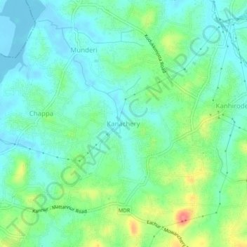
Nome: Mappa topografica Kanachery, altitudine, rilievo.
Luogo: Kanachery, Kannur, Kerala, 670591, India (11.89451 75.42579 11.93451 75.46579)
Altitudine media: 20 m
Altitudine minima: -4 m
Altitudine massima: 70 m
Fai una donazione
Preparati per la tua prossima avventura:
In qualità di associato Amazon, questo sito riceve una commissione sugli acquisti idonei senza alcun costo aggiuntivo per te.
Altre mappe topografiche
Clicca su una mappa per visualizzarne la topografia, l'altitudine e il rilievo.
Kannur
Kannur has an elevation of 1.02 metres or 3.3 feet along the coast of the Laccadive Sea, with a sandy coastal area. The city has an 8 kilometres (5.0 mi)-long seashore and a 3 kilometres (1.9 mi)-long beach at Payyambalam. Kannur is located north of Kozhikode, south of Kasargod and Mangalore, west of the…
Altitudine media: 14 m
Fai una donazione
Preparati per la tua prossima avventura:
In qualità di associato Amazon, questo sito riceve una commissione sugli acquisti idonei senza alcun costo aggiuntivo per te.
Kannur
Kannur has an elevation of 1.02 metres or 3.3 feet along the coast of the Laccadive Sea, with a sandy coastal area. The city has an 8 kilometres (5.0 mi)-long seashore and a 3 kilometres (1.9 mi)-long beach at Payyambalam. Kannur is located north of Kozhikode, south of Kasargod and Mangalore, west of the…
Altitudine media: 14 m