
Mappa topografica Bharuch
Mappa interattiva
Clicca sulla mappa per visualizzare l'altitudine.
A proposito di questa mappa
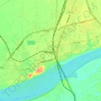
Nome: Mappa topografica Bharuch, altitudine, rilievo.
Luogo: Bharuch, Bharuch Taluka, Bharuch District, Gujarat, India (21.68519 72.96262 21.73299 73.03773)
Altitudine media: 15 m
Altitudine minima: 0 m
Altitudine massima: 38 m
Bharuch is located at 21°42′N 72°58′E / 21.7°N 72.97°E / 21.7; 72.97. It has an average elevation of 15 metres (49 feet). Bharuch is a port city situated on the banks of the Narmada river. The damming of the Narmada caused the original port facilities to close, the nearest port is now in Dahej. The Bharuch district is surrounded by Vadodara (North), Narmada (East) and Surat (South) districts. To the west is the Gulf of Khambhat.