
Fai una donazione
Preparati per la tua prossima avventura:
In qualità di associato Amazon, questo sito riceve una commissione sugli acquisti idonei senza alcun costo aggiuntivo per te.
Mappa topografica Malinao
Clicca sulla mappa per visualizzare l'altitudine.
Fai una donazione
Preparati per la tua prossima avventura:
In qualità di associato Amazon, questo sito riceve una commissione sugli acquisti idonei senza alcun costo aggiuntivo per te.
Malinao
Malinao occupies a narrow stretch of plains hemmed in by Lagonoy Gulf in the east and Mount Malinao on the west. The area is dominated by the mountain ranges of Malinao, with a peak altitude of 1,584 metres (5,197 ft) above sea level. It is 30 kilometres (19 mi) from Legazpi City and 557 kilometres (346 mi) southeast of Manila.
Fai una donazione
Preparati per la tua prossima avventura:
In qualità di associato Amazon, questo sito riceve una commissione sugli acquisti idonei senza alcun costo aggiuntivo per te.
A proposito di questa mappa
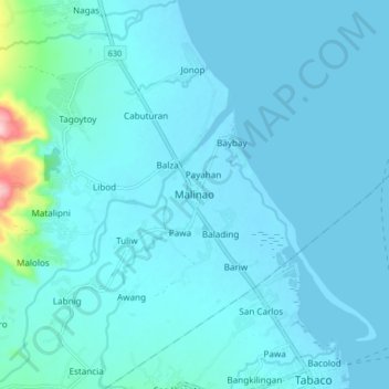
Nome: Mappa topografica Malinao, altitudine, rilievo.
Luogo: Malinao, Albay, Bicol Region, 4514, Philippines (13.35746 123.66498 13.43746 123.74498)
Altitudine media: 17 m
Altitudine minima: -1 m
Altitudine massima: 217 m
Fai una donazione
Preparati per la tua prossima avventura:
In qualità di associato Amazon, questo sito riceve una commissione sugli acquisti idonei senza alcun costo aggiuntivo per te.
Altre mappe topografiche
Clicca su una mappa per visualizzarne la topografia, l'altitudine e il rilievo.
Legazpi
Legazpi's topography is generally plain on the northeastern areas, with slopes ranging from five to fifteen degrees. The southern areas have mostly rolling to hilly terrain. In the city's coastal areas, the terrain varies from plain (north) to hilly (south). Legazpi is criss-crossed by several rivers including…
Altitudine media: 124 m
Manito
Manito is located on the south-eastern tip of Albay, adjoining the south-eastern limit of Legazpi City. The west and NW coast of Manito lies along Poliqui Bay opposite the city of Legazpi. To the north and north-east coast of the municipality lies Albay Gulf. To the east and south of Manito is the province of…
Altitudine media: 121 m
Fai una donazione
Preparati per la tua prossima avventura:
In qualità di associato Amazon, questo sito riceve una commissione sugli acquisti idonei senza alcun costo aggiuntivo per te.
Tabaco
The City of Tabaco is located on the eastern coast of Albay province with an area of 117.14 km2 (45.23 sq mi). The terrain in the poblacion or town center of Tabaco is generally flat with the highest elevation at around 5 m (16 ft). The northwestern portion reaches 400 m (1,300 ft) above sea level. The city's…
Altitudine media: 164 m
Daraga
67.3% of the total municipal land area has a predominantly low elevation of up to 100 metres (330 ft). The surface terrain is generally characterized by combination of level to nearly level areas, gentle to undulating areas and undulating to rolling areas.
Altitudine media: 124 m
Polangui
known during the early times that the barrio has vas and fertile agricultural land, and because of this, settlers from nearby places migrated to this barrio to venture in agricultural farming. One of the early settlers who migrated to this barrio came from barrio La Medalla, town of Iriga (now a City) of the…
Altitudine media: 193 m
Fai una donazione
Preparati per la tua prossima avventura:
In qualità di associato Amazon, questo sito riceve una commissione sugli acquisti idonei senza alcun costo aggiuntivo per te.
Fai una donazione
Preparati per la tua prossima avventura:
In qualità di associato Amazon, questo sito riceve una commissione sugli acquisti idonei senza alcun costo aggiuntivo per te.
Fai una donazione
Preparati per la tua prossima avventura:
In qualità di associato Amazon, questo sito riceve una commissione sugli acquisti idonei senza alcun costo aggiuntivo per te.
Daraga
67.3% of the total municipal land area has a predominantly low elevation of up to 100 metres (330 ft). The surface terrain is generally characterized by combination of level to nearly level areas, gentle to undulating areas and undulating to rolling areas.
Altitudine media: 124 m
Legazpi
Legazpi's topography is generally plain on the northeastern areas, with slopes ranging from five to fifteen degrees. The southern areas have mostly rolling to hilly terrain. In the city's coastal areas, the terrain varies from plain (north) to hilly (south). Legazpi is criss-crossed by several rivers including…
Altitudine media: 124 m
Polangui
known during the early times that the barrio has vas and fertile agricultural land, and because of this, settlers from nearby places migrated to this barrio to venture in agricultural farming. One of the early settlers who migrated to this barrio came from barrio La Medalla, town of Iriga (now a City) of the…
Altitudine media: 123 m
Fai una donazione
Preparati per la tua prossima avventura:
In qualità di associato Amazon, questo sito riceve una commissione sugli acquisti idonei senza alcun costo aggiuntivo per te.
Daraga
67.3% of the total municipal land area has a predominantly low elevation of up to 100 metres (330 ft). The surface terrain is generally characterized by combination of level to nearly level areas, gentle to undulating areas and undulating to rolling areas.
Altitudine media: 124 m
Daraga
67.3% of the total municipal land area has a predominantly low elevation of up to 100 metres (330 ft). The surface terrain is generally characterized by combination of level to nearly level areas, gentle to undulating areas and undulating to rolling areas.
Altitudine media: 124 m
Legazpi
Legazpi's topography is generally plain on the northeastern areas, with slopes ranging from five to fifteen degrees. The southern areas have mostly rolling to hilly terrain. In the city's coastal areas, the terrain varies from plain (north) to hilly (south). Legazpi is criss-crossed by several rivers including…
Altitudine media: 124 m
Fai una donazione
Preparati per la tua prossima avventura:
In qualità di associato Amazon, questo sito riceve una commissione sugli acquisti idonei senza alcun costo aggiuntivo per te.
Legazpi
Legazpi's topography is generally plain on the northeastern areas, with slopes ranging from five to fifteen degrees. The southern areas have mostly rolling to hilly terrain. In the city's coastal areas, the terrain varies from plain (north) to hilly (south). Legazpi is criss-crossed by several rivers including…
Altitudine media: 124 m
Tabaco
The City of Tabaco is located on the eastern coast of Albay province with an area of 117.14 km2 (45.23 sq mi). The terrain in the poblacion or town center of Tabaco is generally flat with the highest elevation at around 5 m (16 ft). The northwestern portion reaches 400 m (1,300 ft) above sea level. The city's…
Altitudine media: 164 m
Fai una donazione
Preparati per la tua prossima avventura:
In qualità di associato Amazon, questo sito riceve una commissione sugli acquisti idonei senza alcun costo aggiuntivo per te.
Tabaco
The City of Tabaco is located on the eastern coast of Albay province with an area of 117.14 km2 (45.23 sq mi). The terrain in the poblacion or town center of Tabaco is generally flat with the highest elevation at around 5 m (16 ft). The northwestern portion reaches 400 m (1,300 ft) above sea level. The city's…
Altitudine media: 164 m
Polangui
known during the early times that the barrio has vas and fertile agricultural land, and because of this, settlers from nearby places migrated to this barrio to venture in agricultural farming. One of the early settlers who migrated to this barrio came from barrio La Medalla, town of Iriga (now a City) of the…
Altitudine media: 123 m
Legazpi
Legazpi's topography is generally plain on the northeastern areas, with slopes ranging from five to fifteen degrees. The southern areas have mostly rolling to hilly terrain. In the city's coastal areas, the terrain varies from plain (north) to hilly (south). Legazpi is criss-crossed by several rivers including…
Altitudine media: 124 m
Fai una donazione
Preparati per la tua prossima avventura:
In qualità di associato Amazon, questo sito riceve una commissione sugli acquisti idonei senza alcun costo aggiuntivo per te.
Legazpi
Legazpi's topography is generally plain on the northeastern areas, with slopes ranging from five to fifteen degrees. The southern areas have mostly rolling to hilly terrain. In the city's coastal areas, the terrain varies from plain (north) to hilly (south). Legazpi is criss-crossed by several rivers including…
Altitudine media: 124 m
Tabaco
The City of Tabaco is located on the eastern coast of Albay province with an area of 117.14 km2 (45.23 sq mi). The terrain in the poblacion or town center of Tabaco is generally flat with the highest elevation at around 5 m (16 ft). The northwestern portion reaches 400 m (1,300 ft) above sea level. The city's…
Altitudine media: 164 m