
Mappa topografica Alice Springs
Mappa interattiva
Clicca sulla mappa per visualizzare l'altitudine.
A proposito di questa mappa
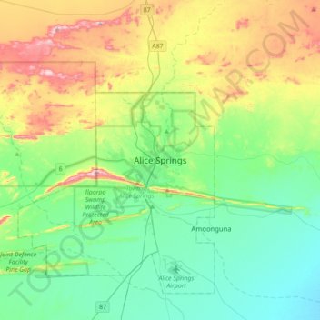
Nome: Mappa topografica Alice Springs, altitudine, rilievo.
Altitudine media: 631 m
Altitudine minima: 505 m
Altitudine massima: 934 m
Temperatures in Alice Springs vary widely, and rainfall can vary quite dramatically from year to year. In summer, the average maximum temperature is in the mid-30s, whereas in winter the average minimum temperature can be 5.5 °C (41.9 °F), with an average of 12.4 nights below freezing every year, providing frost. The elevation of the town is about 545 metres (1,788 feet), which contributes to the cool nights in winter. The highest temperature on record is 47.5 °C (117.5 °F) first recorded on 24 December 1891, whilst the record low is −7.5 °C (18.5 °F), recorded on 17 July 1976. This is also the lowest temperature recorded in the Northern Territory.
Altre mappe topografiche
Clicca su una mappa per visualizzarne la topografia, l'altitudine e il rilievo.
Todd River
Australia > Northern Territory > Alice Springs
Todd River, Alice Springs, Town of Alice Springs, Northern Territory, 0870, Australia
Altitudine media: 632 m
Heavitree Gap
Australia > Northern Territory > Alice Springs
Heavitree Gap, Alice Springs, Town of Alice Springs, Northern Territory, 0870, Australia
Altitudine media: 590 m
Mount Everard
Australia > Northern Territory > Alice Springs
Mount Everard, Alice Springs, Northern Territory, Australia
Altitudine media: 768 m