
Mappa topografica St. Catharines
Clicca sulla mappa per visualizzare l'altitudine.
St. Catharines
The most defining transportation icon of St. Catharines is the Welland Canal, a ship canal that runs 43.4 kilometres (27.0 mi), passing through the city. Four of its locks are within city boundaries. The canal allows shipping vessels to traverse the 99.5-metre (326.5 ft) drop in altitude from Lake Erie to Lake Ontario. The Garden City Skyway is a nearby bridge that facilitates vehicle traffic into the city.
A proposito di questa mappa
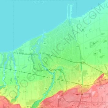
Nome: Mappa topografica St. Catharines, altitudine, rilievo.
Altitudine media: 103 m
Altitudine minima: 70 m
Altitudine massima: 195 m
Altre mappe topografiche
Clicca su una mappa per visualizzarne la topografia, l'altitudine e il rilievo.
Queenston Heights Park
Canada > Ontario > Niagara Region > Niagara-on-the-Lake > Queenston
Altitudine media: 139 m
Wainfleet Lake Erie Public Access Beach
Canada > Ontario > Niagara Region > Wainfleet
Altitudine media: 175 m