
Grazie per il supporto a questo sito ❤️
Fai una donazione
Fai una donazione
Preparati per la tua prossima avventura:
In qualità di associato Amazon, questo sito riceve una commissione sugli acquisti idonei senza alcun costo aggiuntivo per te.
Mappa topografica Timothy Heights
Clicca sulla mappa per visualizzare l'altitudine.
Grazie per il supporto a questo sito ❤️
Fai una donazione
Fai una donazione
Preparati per la tua prossima avventura:
In qualità di associato Amazon, questo sito riceve una commissione sugli acquisti idonei senza alcun costo aggiuntivo per te.
A proposito di questa mappa
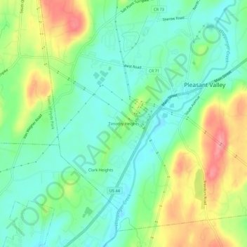
Nome: Mappa topografica Timothy Heights, altitudine, rilievo.
Altitudine media: 87 m
Altitudine minima: 53 m
Altitudine massima: 151 m
Grazie per il supporto a questo sito ❤️
Fai una donazione
Fai una donazione
Preparati per la tua prossima avventura:
In qualità di associato Amazon, questo sito riceve una commissione sugli acquisti idonei senza alcun costo aggiuntivo per te.
Altre mappe topografiche
Clicca su una mappa per visualizzarne la topografia, l'altitudine e il rilievo.
Salt Point
United States > New York > Dutchess County > Town of Pleasant Valley
Altitudine media: 97 m