
Fai una donazione
Preparati per la tua prossima avventura:
In qualità di associato Amazon, questo sito riceve una commissione sugli acquisti idonei senza alcun costo aggiuntivo per te.
Mappa topografica Altenglan
Clicca sulla mappa per visualizzare l'altitudine.
Fai una donazione
Preparati per la tua prossima avventura:
In qualità di associato Amazon, questo sito riceve una commissione sugli acquisti idonei senza alcun costo aggiuntivo per te.
Altenglan
The municipality lies in the uplands in the Western Palatinate on the river Glan, which is the village's namesake, at an elevation in the valley of some 200 m above sea level, although the elevations within municipal limits reach almost 400 m (Bistersberg 387 m on the Glan's left bank; Kalmet 390 m on the Glan's right bank), and on the slopes of the Potzberg within the formerly self-administering municipality of Mühlbach almost 500 m. Altenglan lies roughly 5 km northeast of the district seat and nearest town, Kusel, and 25 km northwest of Kaiserslautern. In Altenglan, the Kuselbach and the Reichenbach empty into the Glan. The dale here forms a broad bowl, although the pattern is broken somewhat by the two streams that meet the Glan here, one from each side. Part of the Potzberg massif lies within Altenglan as does part of the long Remigiusberg ridge, although these hills' summits all lie outside the municipality's boundaries. The municipality has an area of 1 362 ha, of which 237 ha is wooded.
Fai una donazione
Preparati per la tua prossima avventura:
In qualità di associato Amazon, questo sito riceve una commissione sugli acquisti idonei senza alcun costo aggiuntivo per te.
A proposito di questa mappa
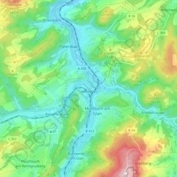
Nome: Mappa topografica Altenglan, altitudine, rilievo.
Altitudine media: 305 m
Altitudine minima: 191 m
Altitudine massima: 561 m
Fai una donazione
Preparati per la tua prossima avventura:
In qualità di associato Amazon, questo sito riceve una commissione sugli acquisti idonei senza alcun costo aggiuntivo per te.
Altre mappe topografiche
Clicca su una mappa per visualizzarne la topografia, l'altitudine e il rilievo.
Schönenberg
Germany > Rhineland-Palatinate > Landkreis Kusel > Schönenberg-Kübelberg
Altitudine media: 266 m