
Mappa topografica Saintfield
Mappa interattiva
Clicca sulla mappa per visualizzare l'altitudine.
A proposito di questa mappa
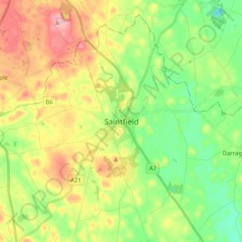
Nome: Mappa topografica Saintfield, altitudine, rilievo.
Altitudine media: 87 m
Altitudine minima: 19 m
Altitudine massima: 187 m
Altre mappe topografiche
Clicca su una mappa per visualizzarne la topografia, l'altitudine e il rilievo.
Newry
United Kingdom > Northern Ireland > County Down
Newry, County Down, Northern Ireland, United Kingdom
Altitudine media: 73 m
Dundonald
United Kingdom > Northern Ireland > County Down
Dundonald, County Down, Ulster, Northern Ireland, BT16 1RH, United Kingdom
Altitudine media: 80 m
Killough
United Kingdom > Northern Ireland > County Down
Killough, County Down, Ulster, Northern Ireland, BT30 7QQ, United Kingdom
Altitudine media: 7 m
Ballynahinch
United Kingdom > Northern Ireland > County Down > Ballynahinch
Ballynahinch, County Down, Ulster, Northern Ireland, BT24 8DN, United Kingdom
Altitudine media: 99 m
Lawrencetown
United Kingdom > Northern Ireland > County Down
Lawrencetown, County Down, Northern Ireland, BT63 6DU, United Kingdom
Altitudine media: 72 m
County Down
United Kingdom > Northern Ireland > County Down
County Down, Northern Ireland, United Kingdom
Altitudine media: 65 m