
Fai una donazione
Preparati per la tua prossima avventura:
In qualità di associato Amazon, questo sito riceve una commissione sugli acquisti idonei senza alcun costo aggiuntivo per te.
Mappa topografica Hothouse
Clicca sulla mappa per visualizzare l'altitudine.
Fai una donazione
Preparati per la tua prossima avventura:
In qualità di associato Amazon, questo sito riceve una commissione sugli acquisti idonei senza alcun costo aggiuntivo per te.
A proposito di questa mappa
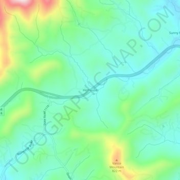
Nome: Mappa topografica Hothouse, altitudine, rilievo.
Luogo: Hothouse, Cherokee County, North Carolina, United States (35.00091 -84.25242 35.04091 -84.21242)
Altitudine media: 624 m
Altitudine minima: 513 m
Altitudine massima: 935 m
Fai una donazione
Preparati per la tua prossima avventura:
In qualità di associato Amazon, questo sito riceve una commissione sugli acquisti idonei senza alcun costo aggiuntivo per te.
Altre mappe topografiche
Clicca su una mappa per visualizzarne la topografia, l'altitudine e il rilievo.
Murphy
United States > North Carolina > Cherokee County
Murphy has a humid subtropical climate, (Cfa) according to the Köppen classification, with hot, humid summers and cool to mild winters, with low temperatures significantly cooler than other parts of the Southeast, due in part to the elevation. Like the rest of the southeastern U.S., Murphy receives abundant…
Altitudine media: 514 m
Murphy
United States > North Carolina > Cherokee County
Murphy is located in southwestern North Carolina, approximately halfway between Atlanta, Georgia and Knoxville, Tennessee. The topography consists of gentle rolling hills and mountains with tall peaks, including ranges from 1800 ft to more than 5000 ft elevation. The location in the Blue Ridge Mountains has…
Altitudine media: 515 m
Andrews
United States > North Carolina > Cherokee County
Until the early 1960s, all Andrews schools were located next to each other on the property of the current elementary school. A 1935 topographic map of Andrews shows each school building, marked with a flag, located adjacent to each other on Walnut Street (now Jean Christy Avenue) and Fourth Street. The current…
Altitudine media: 593 m
Murphy
United States > North Carolina > Cherokee County
Murphy is located in southwestern North Carolina, approximately halfway between Atlanta, Georgia and Knoxville, Tennessee. The topography consists of gentle rolling hills and mountains with tall peaks, including ranges from 1800 ft to more than 5000 ft elevation. The location in the Blue Ridge Mountains has…
Altitudine media: 514 m
Fai una donazione
Preparati per la tua prossima avventura:
In qualità di associato Amazon, questo sito riceve una commissione sugli acquisti idonei senza alcun costo aggiuntivo per te.
Andrews
United States > North Carolina > Cherokee County
Until the early 1960s, all Andrews schools were located next to each other on the property of the current elementary school. A 1935 topographic map of Andrews shows each school building, marked with a flag, located adjacent to each other on Walnut Street (now Jean Christy Avenue) and Fourth Street. The current…
Altitudine media: 593 m