
Mappa topografica Center Harbor
Mappa interattiva
Clicca sulla mappa per visualizzare l'altitudine.
A proposito di questa mappa
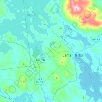
Nome: Mappa topografica Center Harbor, altitudine, rilievo.
Luogo: Center Harbor, Belknap County, New Hampshire, United States (43.66432 -71.58140 43.76098 -71.43989)
Altitudine media: 214 m
Altitudine minima: 150 m
Altitudine massima: 607 m
According to the United States Census Bureau, the town has a total area of 16.3 square miles (42.1 km2), of which 13.3 sq mi (34.4 km2) are land and 3.0 sq mi (7.7 km2) are water, comprising 18.33% of the town. It has several miles of shoreline on Squam Lake and another mile on Lake Winnipesaukee, where its main "harbor" lies. The town center sits eccentrically near Center Harbor's northeast border, where it rises gently from the shore at the junction of New Hampshire Routes 25 and 25B. The commercial district including the town center extends for several hundred yards along NH 25 into the neighboring town of Moultonborough. The highest point in town, Sunset Hill, elevation 1,121 feet (342 m) above sea level, overlooks the town center from the west. Center Harbor lies fully within the Merrimack River watershed.
Altre mappe topografiche
Clicca su una mappa per visualizzarne la topografia, l'altitudine e il rilievo.
Winnisquam
United States > New Hampshire > Belknap County > Tilton
Winnisquam, Tilton, Belknap County, New Hampshire, 03289, United States
Altitudine media: 175 m
Glendale
United States > New Hampshire > Belknap County > Gilford
Glendale, Gilford, Belknap County, New Hampshire, 03249, United States
Altitudine media: 181 m
Weirs Beach
United States > New Hampshire > Belknap County > Laconia > Interlaken Park
Weirs Beach, Interlaken Park, Laconia, Belknap County, New Hampshire, 03247, United States
Altitudine media: 179 m
Lakeport
United States > New Hampshire > Belknap County > Laconia
Lakeport, Laconia, Belknap County, New Hampshire, 03246, United States
Altitudine media: 180 m
Squam Lake
United States > New Hampshire > Belknap County > Center Harbor
Squam Lake, Center Harbor, Belknap County, New Hampshire, United States
Altitudine media: 220 m
Meredith
United States > New Hampshire > Belknap County
Meredith, Belknap County, New Hampshire, 03253, United States
Altitudine media: 215 m
Hopkinson Hill
United States > New Hampshire > Belknap County > Sanbornton
Hopkinson Hill, Sanbornton, Belknap County, New Hampshire, 03269, United States
Altitudine media: 292 m
Lake Manning
United States > New Hampshire > Belknap County > Gilmanton
Lake Manning, Gilmanton, Belknap County, New Hampshire, United States
Altitudine media: 248 m
Sunset Lake
United States > New Hampshire > Belknap County > Alton
Sunset Lake, Alton, Belknap County, New Hampshire, United States
Altitudine media: 268 m
Gilford
United States > New Hampshire > Belknap County
Gilford, Belknap County, New Hampshire, 03249, United States
Altitudine media: 231 m
Laconia
United States > New Hampshire > Belknap County
Laconia, Belknap County, New Hampshire, United States
Altitudine media: 203 m
Sanbornton
United States > New Hampshire > Belknap County
Sanbornton, Belknap County, New Hampshire, 03269, United States
Altitudine media: 228 m
Governors Island
United States > New Hampshire > Belknap County > Gilford > Dockham Shore
Governors Island, Dockham Shore, Gilford, Belknap County, New Hampshire, United States
Altitudine media: 162 m
Alton
United States > New Hampshire > Belknap County
Alton, Belknap County, New Hampshire, United States
Altitudine media: 235 m
Lochmere
United States > New Hampshire > Belknap County > Belmont
Lochmere, Belmont, Belknap County, New Hampshire, 03252, United States
Altitudine media: 173 m
Adams Pond;Adams Pond Dam
United States > New Hampshire > Belknap County > Alton
Adams Pond;Adams Pond Dam, Alton, Belknap County, New Hampshire, 03809, United States
Altitudine media: 252 m
Gilmanton Ironworks
United States > New Hampshire > Belknap County > Gilmanton
Gilmanton Ironworks, Gilmanton, Belknap County, New Hampshire, 03837, United States
Altitudine media: 224 m
Gilmanton
United States > New Hampshire > Belknap County
Gilmanton, Belknap County, New Hampshire, United States
Altitudine media: 257 m
Welch Island
United States > New Hampshire > Belknap County > Gilford
Welch Island, Gilford, Belknap County, New Hampshire, United States
Altitudine media: 153 m
Gunstock Mountain
United States > New Hampshire > Belknap County > Gilford
Gunstock Mountain, Gilford, Belknap County, New Hampshire, 03249, United States
Altitudine media: 456 m
Laconia
United States > New Hampshire > Belknap County > Laconia
Laconia, Belknap County, New Hampshire, 03246, United States
Altitudine media: 227 m
Yale Estates
United States > New Hampshire > Belknap County > Gilford > Yale Estates
Yale Estates, Gilford, Belknap County, New Hampshire, United States
Altitudine media: 390 m
Winona
United States > New Hampshire > Belknap County > New Hampton > Winona
Winona, New Hampton, Belknap County, New Hampshire, United States
Altitudine media: 232 m
Tilton
United States > New Hampshire > Belknap County
Tilton, Belknap County, New Hampshire, United States
Altitudine media: 196 m
Center Barnstead
United States > New Hampshire > Belknap County > Barnstead
Center Barnstead, Barnstead, Belknap County, New Hampshire, 03218, United States
Altitudine media: 183 m
New Hampton
United States > New Hampshire > Belknap County
New Hampton, Belknap County, New Hampshire, 03256, United States
Altitudine media: 264 m
Belmont
United States > New Hampshire > Belknap County
Belmont, Belknap County, New Hampshire, United States
Altitudine media: 232 m
Belknap Mountain
United States > New Hampshire > Belknap County > Gilford
Belknap Mountain, Gilford, Belknap County, New Hampshire, 03249, United States
Altitudine media: 498 m
Alton Bay
United States > New Hampshire > Belknap County > Alton
Alton Bay, Alton, Belknap County, New Hampshire, 03809, United States
Altitudine media: 226 m