
Mappa topografica Anand
Clicca sulla mappa per visualizzare l'altitudine.
Anand
Anand is located at 22°34′N 72°56′E / 22.57°N 72.93°E / 22.57; 72.93. It has an average elevation of 39 metres (127 feet). The city has an area of 22.7 square kilometres, and the urban area of Anand City is 172 square kilometres including 25 villages around the city.
A proposito di questa mappa
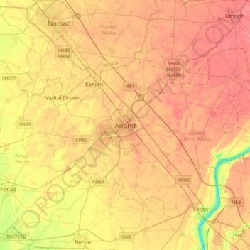
Nome: Mappa topografica Anand, altitudine, rilievo.
Luogo: Anand, Anand City Taluka, Anand, Gujarat, 388001, India (22.39866 72.80272 22.71866 73.12272)
Altitudine media: 40 m
Altitudine minima: 4 m
Altitudine massima: 59 m