
Mappa topografica Southern Uplands
Clicca sulla mappa per visualizzare l'altitudine.
A proposito di questa mappa
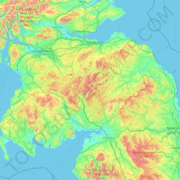
Nome: Mappa topografica Southern Uplands, altitudine, rilievo.
Altitudine media: 161 m
Altitudine minima: 0 m
Altitudine massima: 1.105 m
Altre mappe topografiche
Clicca su una mappa per visualizzarne la topografia, l'altitudine e il rilievo.
Garden of Cosmic Speculation
United Kingdom > Scotland > Dumfries and Galloway > Burnhead
Altitudine media: 31 m
Rhinns of Kellsc
United Kingdom > Scotland > Dumfries and Galloway
'Rhinns' derives from the Old Irish rind, later Ulster Irish and Scottish Gaelic rinn, meaning 'promontory' or 'point'. 'Kells' is a parish in the historic county of Stewartry of Kirkcudbright to the southeast of the range near New Galloway. Its name possibly derives from the Old Irish cell, later Irish and…
Altitudine media: 352 m