
Mappa topografica Sonamarg
Mappa interattiva
Clicca sulla mappa per visualizzare l'altitudine.
A proposito di questa mappa
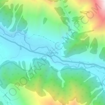
Nome: Mappa topografica Sonamarg, altitudine, rilievo.
Luogo: Sonamarg, Kangan, Ganderbal district, Jammu and Kashmir, India (34.28239 75.27656 34.32239 75.31656)
Altitudine media: 3.068 m
Altitudine minima: 2.639 m
Altitudine massima: 4.240 m
The hill station is situated in the Kashmir Valley, at an altitude of 2,730 metres (8,960 ft) and is close to some of the valley's tallest peaks, alongside the Machoi Glacier, Sirbal Peak, Kolahoi Peak, Amarnath Peak and Machoi Peak. Combined with the alpine meadows that bloom in the summer as well as rivers and lakes stocked with fish, Sonamarg is a notable tourist destination in Jammu and Kashmir.
Altre mappe topografiche
Clicca su una mappa per visualizzarne la topografia, l'altitudine e il rilievo.
Gagangir
India > Jammu and Kashmir > Kangan
Gagangir, Kangan, Ganderbal district, Jammu and Kashmir, India
Altitudine media: 2.795 m
Kangan
India > Jammu and Kashmir > Kangan
Kangan, Ganderbal District, Jammu and Kashmir, India
Altitudine media: 3.335 m